

Where in Duluth? Watercolor edition.
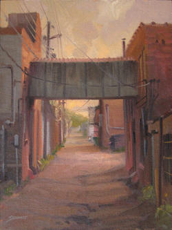
The Skyway, Brian Stewart from https://www.stew-art.com/pleinair.htm
I came across this water color image from Brian Stewart while engaging in my newest time trap, curating the “Duluth-o-Philia” board on Pinterest. This does evoke a location for me, but for the life of me, I can’t remember the place. Bonus question, is it still there even?
I believe right here, but from the opposite side.
Just glancing at it reminds me of the connection over the ally between the DeWitt-Seitz Marketplace and whatever that other building is called where Little Angie’s Cantina is. But, that is obviously not it as neither building is big enough and the development is all wrong.
The alley behind the Bedrock.
That is an excellent collection of photos on your Pinterest board.
I’m thinking possibly right here, but I can’t find anything closer.
I’m thinking that Zeito and Sjixxxy have the same location, is that right? Only, the angle seems wrong in Sjixxxy’s photo, could that be a lighting trick? An artistic license by the painter? Or is it somewhere else. I can’t picture the spot C-Freak suggests. And thanks, DaVe, I do love this town. I particularly have enjoyed finding the stuff that is beyond the typical, although even Canal Park and the harbor are still beautiful to me and I’ve been seeing them much of my life.
It reminded me of the same location, Sjixxxy, but that skywalk is at a 45 degree angle. It also reminded me of the one in Canal Park, but as edgeways said, it obviously isn’t.
I’ve only noticed the one Zeito mentions once or twice, so I’m not very familiar with it. It looks right from the pictures, though: it’s close to the front of the buildings, the power lines run down left side of the alley, there’s a small “tower” (roof access? elevator shaft?) on the left building, an open space before the building on the left, an open space after the building on the right, and a one-story building before the building on the right.
As an aside, I like the skywalk in Canal Park because it’s two stories.
This is in the alley behind the old R bar site looking east toward the ATT building. This skywalk used to connect the old Chinese Lantern I on Superior street to the Chinese Lantern II which is the R bar site.
c-freak is correct and the rest of you are wrong. It’s the alley behind the Bedrock. The walkway is still there today, though slightly modified, with a shiny aluminum panel in the middle. You can even see the dumpster behind Curly’s in the painting.
Nice picture.
That’s my old stomping grounds. I burned a lot of doobs back there.
Isn’t Zeito’s map the alley behind the Bedrock? The streets visible in the map are 20th and 21st Avenues West and Superior and First Streets.
If I’m remembering correctly, the skywalk goes to some sailors’ building. Is that right?
For reference, Sjixxxy’s is on Second Avenue West looking east down the alley above First Street.
There used to be several of those vintage “skywalks” downtown, out west and even in the canal area when it was all scrap yards and industrial biz.
Zeito’s map is indeed of the Bedrock Bar area.
Zeito and c-freak are right and the rest of you are wrong.
This Brian Stewart guy is pretty damn good, by the way.