
Reports – Studies – Plans
Report scores Minnesota’s progress in sustainability
 Minnesota’s state agencies are making progress toward sustainability goals according to a report by the Department of Administration’s Office of Enterprise Sustainability.
The Enterprise Sustainability 2017 Annual Report is the first collection of data that documents progress on cutting costs and increasing efficiency through sustainable practices.
The report can be viewed online at mn.gov.
Creative Minnesota releases report on arts economy

Creative Minnesota has released its second biennial economic report. The effort is a collaboration of arts and culture funders in partnership with Minnesota Citizens for the Arts with the goal is to “create solid, hard data about the arts sector.” The data is collected for “analysis, education and advocacy.” (more…)
Lower Spirit Mountain Riverfront Park Site Plan released
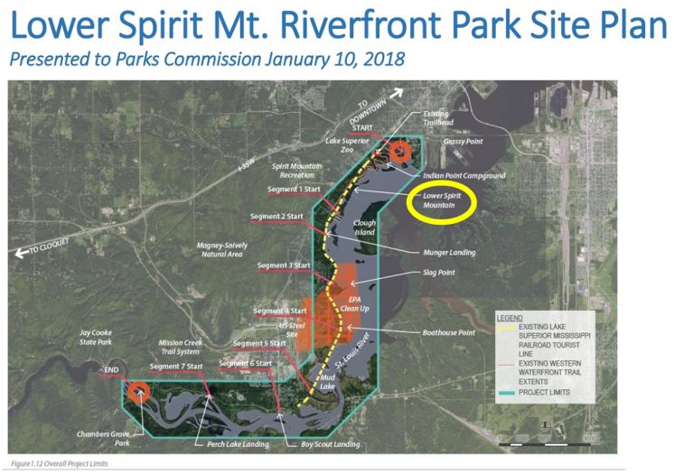
The nine-page Lower Spirit Mountain Riverfront Park Site Plan was presented to the Duluth Parks Commission on Jan. 10 and the city’s Parks and Recreation Division is seeking public comment on it until Jan. 31. A final draft of the plan will be presented and voted on at the Feb. 14 Parks Commission meeting.
The site sits below the BNSF Railroad, opposite Tallus Island in Duluth’s Riverside neighborhood, and has approximately 1,500 ft. of shoreline to the St. Louis River. (more…)
Irving Fairmount Brownfields Revitalization Plan
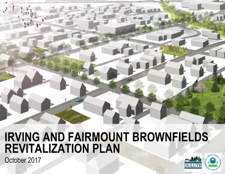 The Duluth City Council adopted the Irving Fairmount Brownfields Revitalization Plan on Dec. 11. Irving and Fairmount are sub-neighborhoods of West Duluth.
The video above shows clips from a gathering on Oct. 18 at Loll Designs headquarters marking the completion of the plan.
The planning effort focused on redevelopment of post-industrial sites, infrastructure improvements, creating better connections to the Spirit Valley commercial area and increasing walkability.
DuluthiLeaks: Historic Bridge Report for DM&IR Ore Dock No. 5
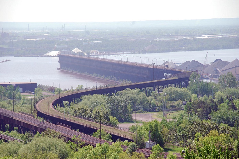

How historically significant is West Duluth’s old ore dock and its viaduct and bridges? The Minnesota Department of Transportation retained the consultant team of LHB, Mead & Hunt and 106 Group to produce a multi-purpose study in 2014 that was part of a more comprehensive process involving numerous agencies looking at 140 historic bridges. Part of the goal of the “Local Historic Bridge Report” for the “DM&IR Ore Dock No. 5 Approach” was to gather historical information should the property owner — Canadian National Railway — wish to request a nomination be prepared for the National Register of Historic Places.
For the third edition of DuluthiLeaks — Perfect Duluth Day’s feature in which public documents are released as if they contain secret information leaked from an anonymous whistle blower — we peak into a study of four steel-beam bridges that are part of the mile-long approach to DM&IR Ore Dock No. 5. (more…)
Public input sought on Duluth Traverse mini-master plan
The city of Duluth is compiling comments for the draft Duluth Traverse Trail Management and Mini-Master Plan and is seeking input on expanded mountain bike trail offerings with a goal of 100 miles of trails, bike skills park construction sites and improved/expanded neighborhood trail access and facilities such as expanded parking, showers and signage. (more…)
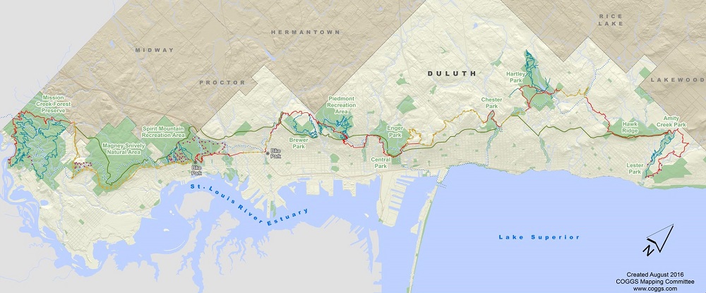
Duluth Cross City Trail plan reveals new West Duluth route
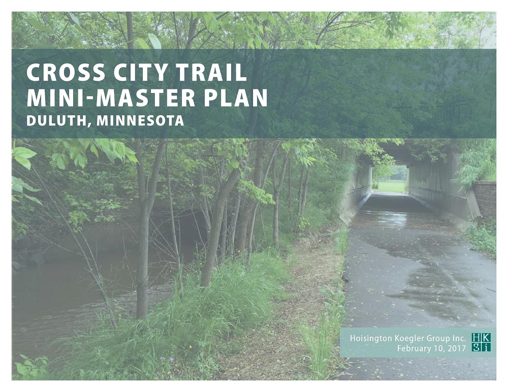 The final draft of the Cross City Trail Mini-Master Plan was released today by Duluth’s Parks and Recreation Division. It outlines the vision for a 10.3-mile multi-purpose paved trail system that connects the Duluth Lakewalk with the Willard Munger State Trail. Much of the trail has already been constructed over the past five years.
The plan is the culmination of more than 12 years of planning and development work. The public entered the process in 2010, when maps of potential routes were released for feedback. Several controversial alternate routes through West Duluth were discussed in the ensuing years when certain right-of-ways became unavailable, but a new route similar to what was initially presented has emerged.
Pending approval of the plan by the Duluth City Council, construction will start on a major new segment called the “River Route,” which will run from the current western end of the Cross City Trail at Carlton Street, under the ore docks, across Interstate 35 and through the riverfront area. The new segment will end at Irving Park. Two proposed connecting trails would create a loop between Irving and the Munger Trail terminus that would include a section completed last summer on the DWP Trail. (more…)
Ethnographic Study of Indigenous Contributions to Duluth
 Last night at Gimajii, the Design Duluth meeting sponsored by the DAI shared copies of An Ethnographic Study of Indigenous Contributions to the City of Duluth — a fascinating document that invites us to think about the erasure of indigenous participation and contributions to Duluth culture — and to appreciate those contributions and participation even more heartily. (more…)
Cross City Trail Master Plan
![]() Interested in connecting the Lakewalk with the Munger Trail? Now is the time to give your thoughts on which route or combination of routes you like for the West Duluth segment. The city has four routes for you to comment on. Visit the Cross City Trail website and take the survey.
Interested in connecting the Lakewalk with the Munger Trail? Now is the time to give your thoughts on which route or combination of routes you like for the West Duluth segment. The city has four routes for you to comment on. Visit the Cross City Trail website and take the survey.
The Trails/Parks Committee of the River Corridor Coalition has videos of the entire river route broken into seven segments, along with an interactive map to help identify where the segments are. Visit crosscitytrailduluth.com to check it out. This is the lesser known route that is harder to find and understand, so be sure to check it out.
The city wants your input, so go to the survey and participate. This is a regionally significant trail connection, connecting two great state trails, the Munger Trail and Gitchi-Gami Trail. When all is complete you can go from Hinckley to the Canadian border.