Mystery Photos #85-87: Probably Skyline Parkway in the 1920s
An early 20th Century family photo album was recently unearthed in the Nicklawske archive room and I discovered some old Duluth photographs. I pulled three pictures from the book that included images of an automobile trip my grandfather and his sister made to Duluth in the 1920s. My grandfather, Jim Nicklawske, lived in St. Paul at the time and his sister Mae was visiting from her home in Great Falls, Mont. It appears they traveled to Duluth with a third, unidentified person who made pictures of the event.
One picture shows a common Skyline Drive view of downtown Duluth with Minnesota Point in the background.

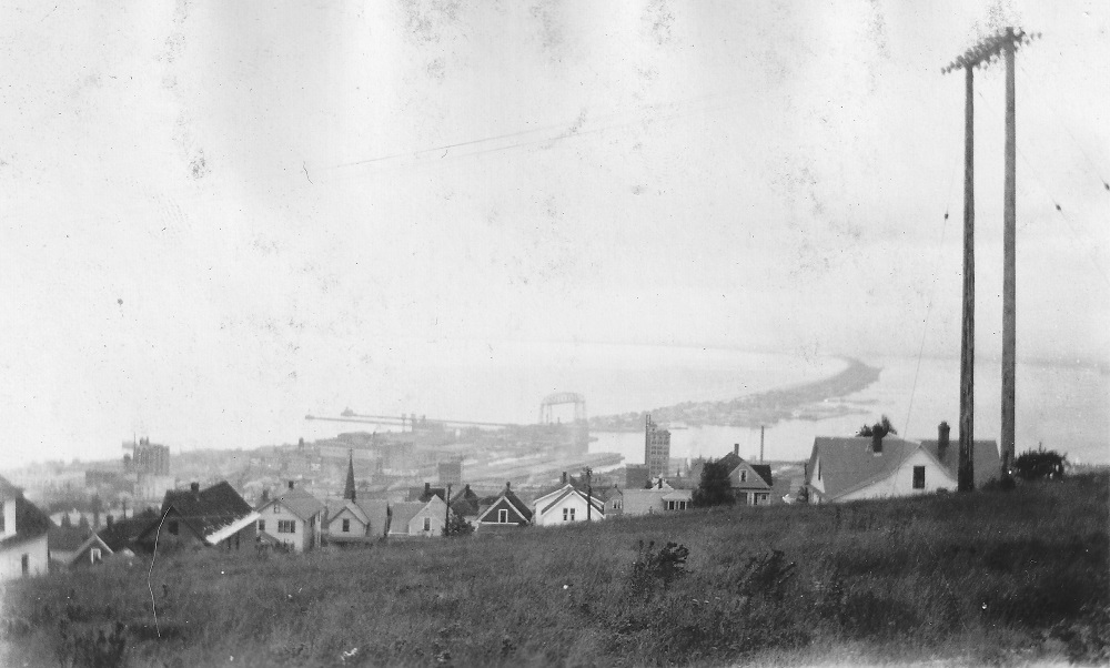
A second photo was taken from an unknown location east of downtown with a strange stretch of flat, grassland in the foreground.
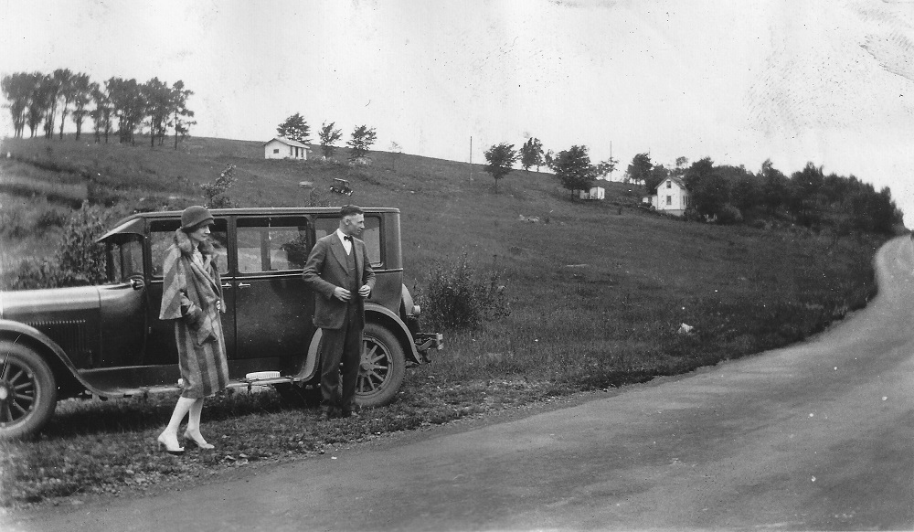
The third photo, which features what I believe to be a 1926 or 27 Dodge sedan, is a real mystery.
Questions:
1) What year were these photos taken?
2) What and where is the grassy knoll in the second photo?
3) What part of Skyline Drive is pictured in the third photo with the Dodge sedan? There appears to be antennas in the background. Could it be the start of the antenna farm? Maybe somewhere near the Central Entrance and Mesaba/Rice Lake intersection?
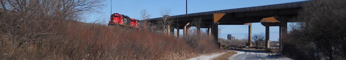
I don’t think the exact date is possible but it’s certainly before 1929 as that’s when the Aerial Bridge (seen in the 1st picture) became the Aerial-Lift Bridge.
Photo #2 looks to have been taken just east/south of Chester Bowl. The two prominent buildings in the background flanking the ore carrier, I’m guessing are Holy Rosary Church (on the right) and East H.S. (on the left).
My guess for photo#3 Is near where 10th Ave. West/Observation Road intersects with Skyline Parkway today.
The second photo holds many clues. The building with the tower right of center is St. Anthony of Padua Catholic Church at 1030 East 8th Street, built in 1922-23; the commercial building left of center is Munger Elementary School at 1120 East 8th Street, built in 1914. And as Mark Ryan wrote, the aerial bridge shown in photo #1 is still a transfer bridge; conversion of the bridge began in August, 1929.
1. So the picture in the center was taken between 1923 and August, 1929, and if these were a set taken at the same time, I imagine the other two are from the same time. If that is indeed a 1926 or ’27 Doge, then I’d guess between 1926 and 1929.
2. That “grassy knoll” is the wayside along the Boulevard, which was renamed Skyline Parkway in 1929, roughly between 11th and 10th Avenues East. It’s still there today, but paved.
3. No idea. Both Marks have made valid suggestions.
Well, this is coming in a bit late, but photo number three seemed to have enough information to figure out and I was in the mood for trying to solve a mystery photo, so better late than never, I suppose.
The streets below the antenna farm tend to have a lot of rocky outcroppings, and not a single rock formation is visible in the rather panoramic view provided by the third photo, so I decided to look at other locations with the assumption that those were just normal utility poles in the background and not giant antennas.
Starting with Mark Ryan’s suggestion of a location near Central Entrance and Rice Lake Road, I used the oldest available aerial photos of the area to look for a large grassy hill with limited development.
I found a spot that seemed to match almost immediately, on Skyline Parkway just east of Kenwood Avenue.
The house currently at 1215 E. Skyline Parkway seems to be the house in the photo. The present day house at that location is somewhat larger than in the photo, but this makes sense as the home, built in 1919 and therefore standing at the time of the photo, was remodeled in 1940 according to realtor.com.
Several small details match precisely, including the basement window and the low dormer projecting from the center of the roof.
The neighboring house wasn’t built until 1955 and all the other houses on this section of Skyline Parkway, all with street facing garages built into the design of the house, also seem to have been constructed much more recently, suggesting there was a time when the house at 1215 would have been the only one on the hill.
The final bit of support for this location is that it corresponds almost exactly with the location of the second photo, taken on Skyline looking down between 11th and 12th Avenue East (between the St. Anthony’s and the old Munger School, visible in the background of the second photo, as noted by Tony). This adds a little to the narrative of the photos, suggesting that the photographer took a picture of his or her traveling companions while stopping for a picture of the view.
And although it wasn’t asked, I might as well add that the first photo was taken on Skyline Parkway near the intersection of West Eighth Street. The row of houses in the middle foreground are the houses on West Seventh Street between Third and Second avenues west and all of them are still standing, with the exception of the white house toward the right.