
Matthew James
Superior Street, Sept. 11, 1907, Part 4: The 400 West Block
This series takes a detailed look at life on Superior Street on the afternoon of Wednesday, Sept. 11, 1907. The first part of the series provided background details on the photograph itself. Part three looked at the businesses around the Spalding Hotel. Part four looks at the people who occupied the remainder of the Spalding block, including “old Nick Drew, erstwhile gambler, rounder and saloon-keeper.” (more…)
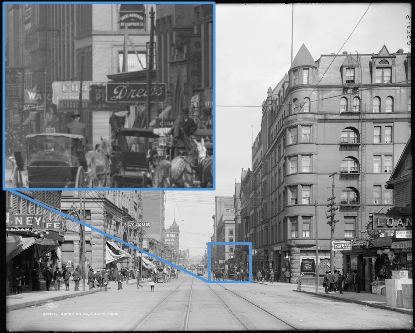
Superior Street, Sept. 11, 1907, Part 3: Spalding Hotel and Surrounding Businesses
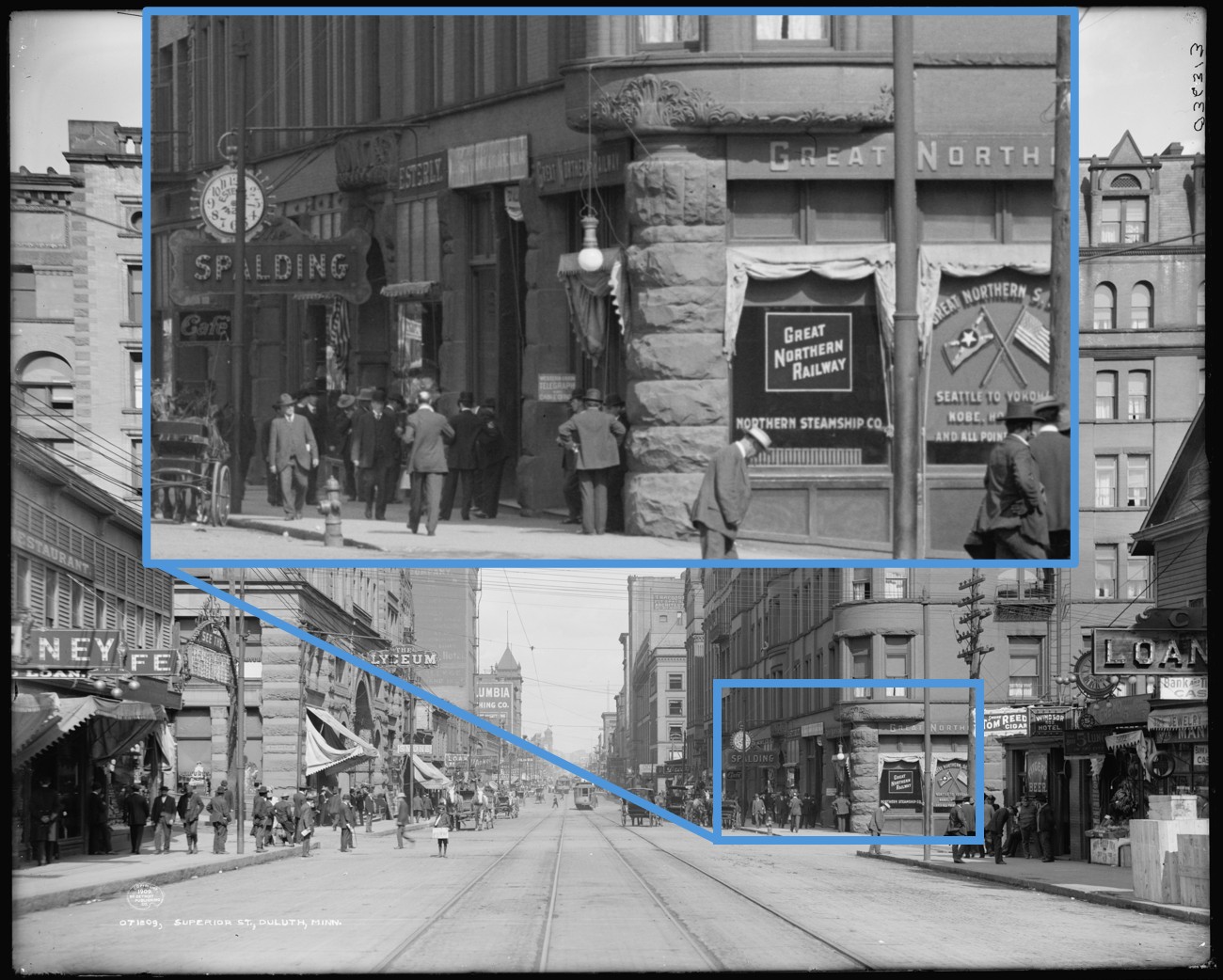
This series takes a detailed look at life on Superior Street on the afternoon of Wednesday, Sept. 11, 1907. The first part of the series provided background details on a photograph shot that day where the street intersects Fifth Avenue West. Part three focuses on the businesses around the Spalding Hotel, including a fight with the city over on-street parking policies by a watchmaker whose pocket watches are still prized by collectors today. (more…)
Superior Street, Sept. 11, 1907, Part 2: The Windsor Hotel and Surrounding Businesses
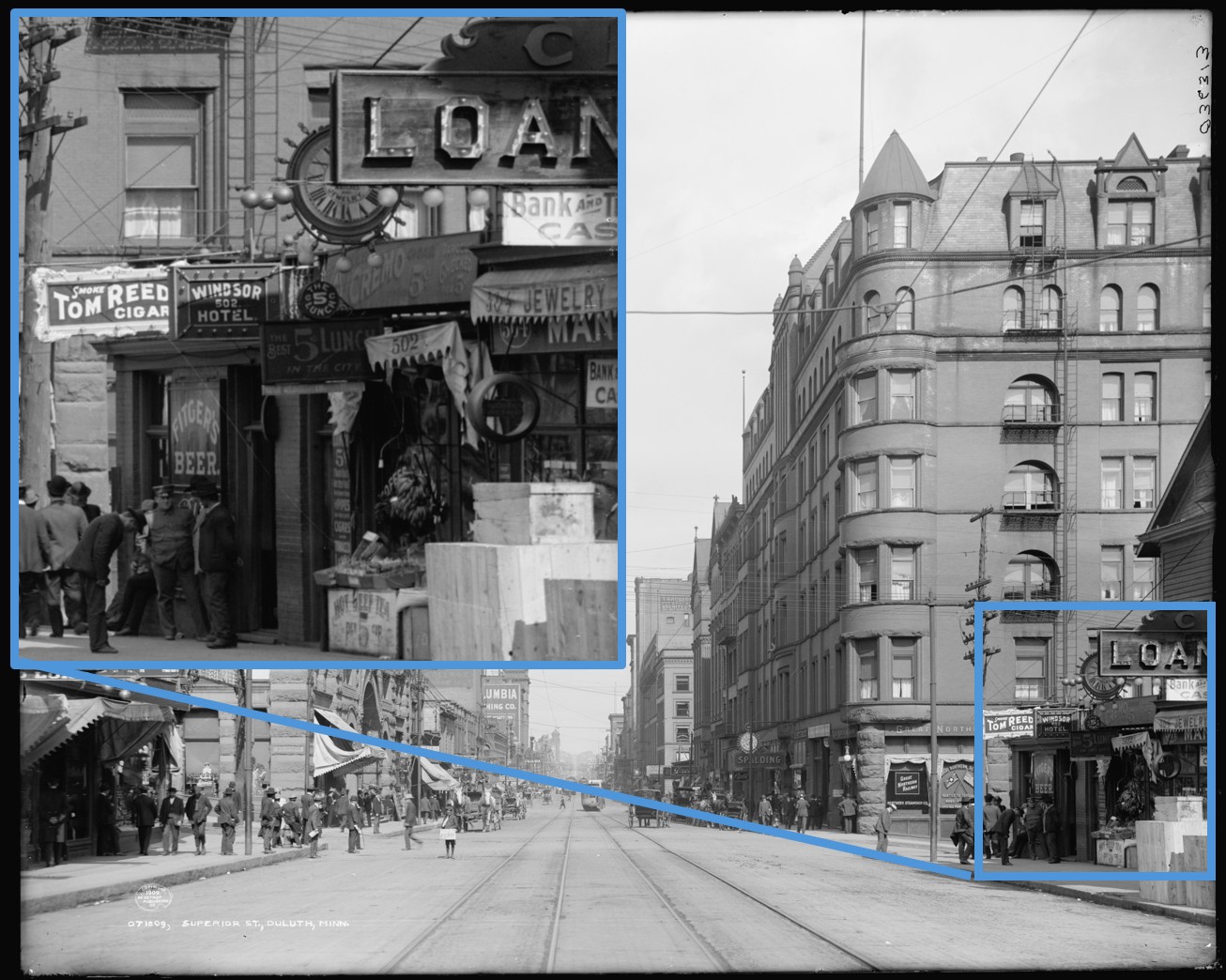
This ten part series takes a detailed look at life on Superior Street on the afternoon of Wednesday, Sept. 11, 1907 based on a single photograph. The first part of the series provided background details on the photograph itself. Part two focuses on the bottom right corner of the photograph, relating to the contentious history between the city and the owner of the Windsor Hotel and telling the stories of the surrounding businesses. (more…)
Superior Street, Sept. 11, 1907, Part 1: Introduction
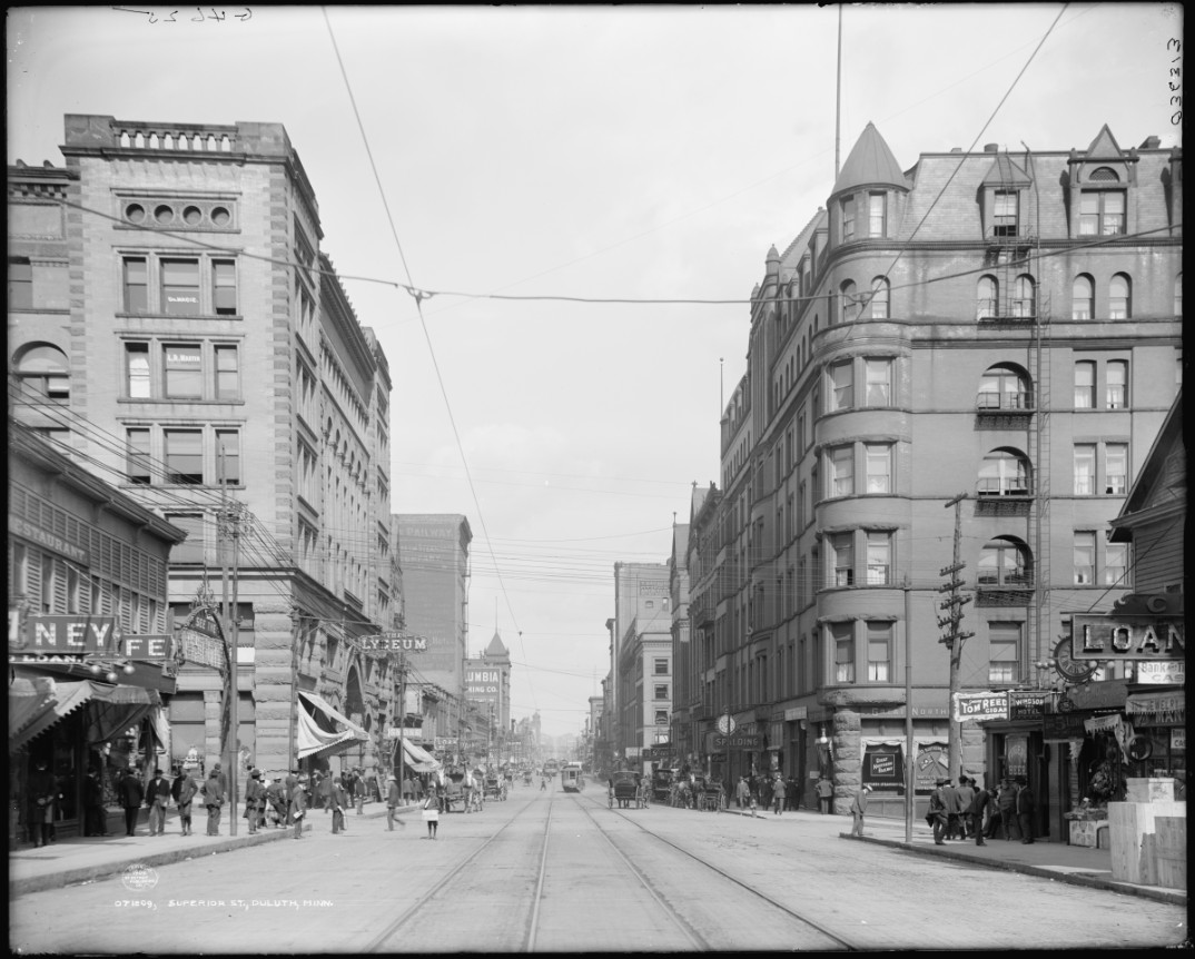
Superior Street, 1907.
The image above comes from a high resolution scan of Superior Street looking east toward Fifth Avenue West. It has been shared online many times before, including on Perfect Duluth Day. For those who have wondered about the businesses visible and half-hidden in the photo and the stories behind them, this series has some answers. Using the Minnesota Digital Newspaper Hub to match photo elements with newspaper articles, it describes a maritime birth, a crooked pawn shop owner, and an ingenious inventor in its tales of both incredible wealth and stark poverty on Superior Street in 1907. (more…)
The Imperatur YouTube channel focuses on Duluth
https://www.youtube.com/watch?v=A6XPh4t-kYs
A popular YouTube channel based out of Germany features “mini documentaries about cities and infrastructure around the world.” It recently posted an episode on the urban planning challenges faced by Duluth. Within the rapid 9-minute overview, there is a lot that is correct. And there is just as much to quibble about, which is often the more fun part of watching videos like this.
Duluth Deep Dive #14: The Last of the Transporter Bridges
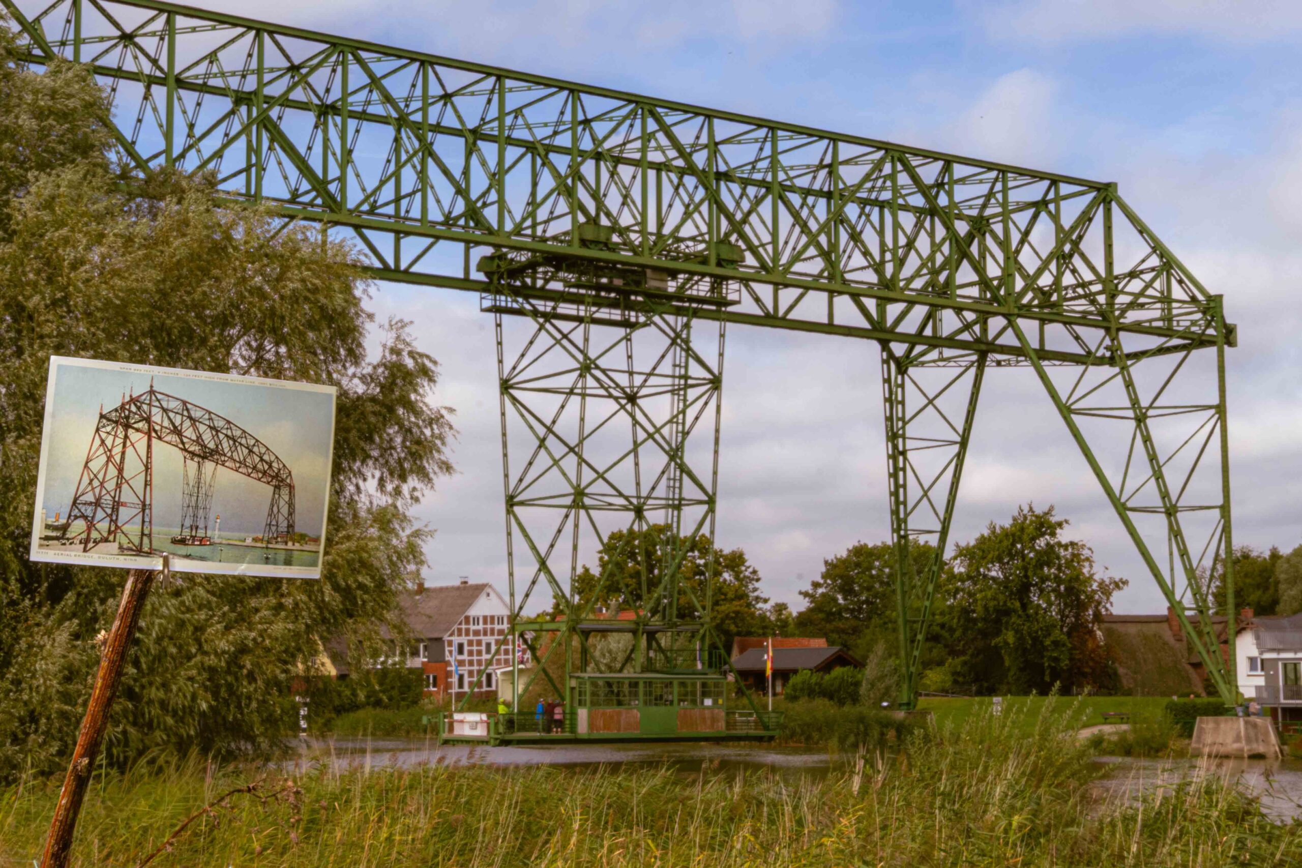
Germany’s Osten-Hemmoor Bridge with a postcard of Duluth’s transporter bridge in the foreground. (Photo by Matthew James; postcard from the University of Minnesota Duluth, Kathryn A. Martin Library, University Archives)
Growing up in Duluth, I often heard that the lift bridge was the only bridge of its type in the world. I later learned that the world is full of lift bridges. Wikipedia lists 137 of them. But that doesn’t mean the claim isn’t true. The lift bridge was once a transporter bridge, a far more rare type of bridge. Aside from various hand-cranked bridges that basically amount to art projects, fewer than two dozen transporter bridges have ever been built anywhere in the world. Only eight of those are still in use. And the world only has one converted transporter bridge in operation: Duluth’s Aerial Lift Bridge. This Duluth Deep Dive takes a closer look at what Duluth’s bridge was like before its conversion by recounting my visit to two of the world’s remaining transporter bridges. One is the closest surviving counterpart to Duluth’s original canal bridge. The other gives a sense what the Duluth bridge might have looked like if the city had modernized the gondola instead of making the conversion to a lift bridge. (more…)
Duluth Deep Dive #13: Henry C. Richardson, Civil Rights Pioneer

A Black man, left, crosses Superior Street circa 1908. (Source: Library of Congress)
In 1904, more than 50 years before Rosa Parks refused to give up her seat on a Montgomery, Alabama bus, Henry Richardson fought against the common practice in Duluth restaurants to refuse service to people of color. When a waitress at a Superior Street restaurant would not take his order, he took the restaurant owner to court. This Duluth Deep Dive recounts the events and their aftermath. (more…)
Duluth Deep Dive #12: Ads from the Archives

Duluth Evening Herald, June 18, 1909; Sept. 5, 1899; Oct. 31, 1908.
While putting together the Duluth Deep Dives, I often come across ads in the Minnesota Digital Newspaper Hub that I find amusing, surprising, well-designed or a direct reflection of the historical period. When I see one of these ads, I make a clip and put it aside in a folder. In what seems likely to be a reoccurring topic, this Duluth Deep Dive goes into those files to present 20 somewhat remarkable ads. (more…)
Duluth Deep Dive #11: When the Hollow Concrete-Block Building Boom Came to Duluth
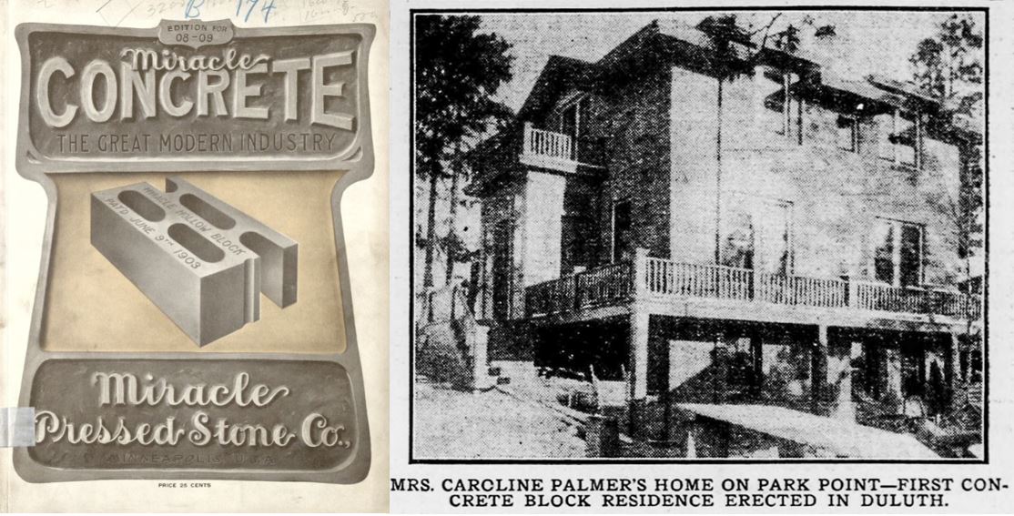
Left: Cover of the 1908 catalogue for the Miracle Pressed Stone Company of Minneapolis; Right: The first hollow concrete-block house in Duluth. (Sources: The Minnesota Digital Library; The Duluth Evening Herald, Feb. 3, 1906)
A few months ago a friend of mine from elementary school moved into a house on Park Point. When he asked me to help look into its history, we learned he had purchased the first hollow block concrete home ever built in Duluth, and one of the oldest still standing in Minnesota. This Duluth Deep Dive looks at the start of the hollow concrete-block building boom in Duluth and where it led. It describes the links between local concrete homes and the Duluth shipping canal. It also challenges the claim that Duluth had the first concrete streets in Minnesota. (more…)
Duluth Deep Dive #10: The Life, Work and Legacy of Edwin Samuel Radcliffe, Early Duluth Architect

A blog post on the history of Keller Row in St. Paul notes that not much is known about its architect, Edwin S. Radcliffe, who spent most of his career in Duluth. This Duluth Deep Dive counters that assertion by providing the most complete record of his life and works available online. It uses articles from the Minnesota Digital Newspaper Hub, reports by the Duluth Heritage Preservation Commission, and Tony Dierckins and Maryanne C. Norton’s book Duluth’s Grand Old Architecture to not only look at the buildings he created, but how his life and work intersected with important, surprising and trivial events in Duluth and Minnesota history. It includes stories of churches, schools, department stores, an Indigenous boarding school, a saloon and a brothel, along with an interactive map of all his known buildings. It also recounts the known events from Radcliffe’s life, including his participation in the Blueberry War of 1872, his patent on a device to make bathrooms less smelly, and the massive community card games held in his Park Point home. (more…)
Duluth Deep Dive #9: The Third Largest City in Minnesota

The population of Duluth, Bloomington, and Rochester over time (Source: U.S. Census Data)
A recent YouTube video on Duluth restaurants described Duluth as the third-largest city in Minnesota — a statement that has been true at various points in the state’s history. Since Minnesota became the 32nd state in 1858, Minneapolis and St. Paul have consistently been its two largest cities. Third place, however, has been considerably less stable. This Duluth Deep Dive takes a closer look at the cities that have held the #3 spot, using aerial images to show how these cities have developed over time. (more…)
Duluth Deep Dive #8: The Duluth Herald, Sept. 7, 1925

A classified ad from the Duluth Herald on Sept. 7, 1925. It’s not clear if anyone took up the offer on the grocery store.
Perfect Duluth Day often features individual stories from historical newspapers. This Duluth Deep Dive looks at the whole paper, adding context where necessary to the notable stories from a single edition of the Duluth Herald published one hundred years ago today, including a massive Klan rally in southern Minnesota, arrests by the Duluth Purity Squad, and highlights from the film, sports and classifieds listings. (more…)
Duluth Deep Dive #7: The Duluth Garage

Artwork on a Duluth garage. (Photo by Matthew James)
A friend of mine is putting her childhood home up for sale<, a house in one of Duluth's older neighborhoods with an attached garage. She realized that she wanted her next home to be a similar-style house with that same convenience of not having to go outside to start the car in the winter, but the options in Duluth were very limited. This post places the changing role of the home garage in the context of Duluth history to explain why. (more…)
Duluth Deep Dive #6: Superior Street in Six Acts

Superior Street around 1873. (Photo from the Northeast Minnesota Historical Collection)
The downtown section of Superior Street has a more complete photographic record than any other part of the city, revealing how dramatically Duluth’s main street has changed over time. This Duluth Deep Dive traces the 170-year history of downtown Superior Street by dividing its history into six periods and illustrating each period with a photo. (more…)
Duluth Deep Dive #5: The Life and Times of William Sheldon Storer, Early Duluth Dentist

Dr. Storer came to Duluth from New York in 1893, where he set up practice as a local dentist. This post uses the Duluth Herald archives to recount notable events from his life, including his legal battle with Dr. Laird’s Travelling Medicine Show, his second marriage to a locally renowned German dietitian, and his role in what the original Duluth Rip-saw referred to as the “worst war in the glorious history of Lester Park.” (more…)
Duluth Deep Dive #4: A Rock on Fourth Street

A rock on a section of undeveloped land on Fourth Street between Seventh and Eighth avenues east. (Photo by Matthew James)
There are a lot of rocks, large and small, strewn about Duluth. This post uses the assistance of ChatGPT, backed-up by a moderate amount of fact checking, to figure out what can and cannot be known about this particular one. (more…)
Duluth Deep Dive #3: Bob Dylan and the Minnesota Digital Newspaper Hub

Bob Dylan’s father leads a dance in Duluth, The Duluth Herald, October 28, 1931.
The free, open access, online Minnesota Digital Newspaper Hub, supported by recently cut grants from the National Endowment for the Humanities, lets you do your own deep dives into genealogy, the history of a home or business, or just about anything that has happened in Duluth or throughout Minnesota. This month’s deep dive shows you how the site works by using Bob Dylan’s Duluth family history as an example. (more…)
Duluth Deep Dive #2: Duluth’s Duluthiest Brands

Some of Duluth’s Duluthiest beanies. (Photo by Matthew James)
Perfect Duluth Day is indisputably Duluth’s Duluthiest website but what is Duluth’s Duluthiest brand? This post takes a look at some contenders for the brand that best conveys a sense of Duluthiness. (more…)
Duluth Deep Dive #1: Sandbars

From top to bottom, freshwater sandbars in Lake Eerie, Lake Baikal and our own on Lake Superior. In each image, the red line represents 15 miles. (Images from Google Earth)
The 10-mile combined length of Minnesota and Wisconsin Point is often described as one of the world’s longest natural freshwater sandbars. But which sandbars is it being compared against? This post takes a closer look at the world’s longest sandbars (and includes a Geoguessr challenge of remarkable sandbars around the world). (more…)
PDD Geoguessr becomes Duluth Deep Dive (with a Geoguessr)

PDD Geoguessr is getting a rebranding for 2025. Last year’s analytics showed that a lot more people were reading the context around the games than playing the games themselves. In recognition of this, the new monthly format will put more focus on the topic rather than just providing a link for the game. To keep the posts connected to cultural geography — and to show some appreciation to the dedicated PDD Geoguessr players — the posts will still conclude with a Geoguessr challenge. This announcement marks the transition with a Geoguessr challenge that fits the old format better than the new one. (more…)
Jo Koy tours Downtown Duluth
On Saturday, Jan. 25, comedian Jo Koy performed at the Duluth Entertainment Convention Center. He seems to have used the opportunity of the booking to explore the city a bit and make some content for his Instagram channel.
PDD Geoguessr #34: Alan Sparhawk on Tour

Alan Sparkhawk and son Cyrus at a performance in Amsterdam on March 3, 2025 (Photo by Matthew James)
Alan Sparhawk is on tour again this week, and this post briefly discusses his new album, including Geoguessr challenges looking at the five locations where he is scheduled to play over the next seven days and another looking at the upcoming European leg of his tour.
(more…)
PDD Geoguessr #33: Walking Shortcuts

This Duluth avenue is unlikely to be open to car traffic any time soon. (Photo by Matthew James)
Over the past 100 years, the increase in car use has changed the Duluth landscape. Downtown has fewer shoppers walking the streets and traffic is heavy on the roads to the big box stores at the top of the hill. Whole neighborhoods have been torn down to make room for highways. But the particular geography of Duluth has resulted in a number of urban routes open only to people walking (and, for some, also biking). This post takes a closer look at a few of those locations and concludes with a Geoguessr game testing your knowledge of travel routes in Duluth closed to cars. (more…)
PDD Geoguessr #32: The 1984 Duluth City Directory

The 1984 Duluth City Directory (Photo by Matthew James)
As 2024 comes to a close, this post takes a look at Duluth 40 years ago using the 1984 Polk Directory of Duluth as an example for examining the history and use of city directories. This post includes ads from the directory for five businesses that have since left Duluth and five that still remain. It then concludes with two Geogeussr challenges featuring the historical locations of these ten businesses. (more…)
PDD Geoguessr #31: Gridlock

An intersection of grids along North Central Avenue near Denfeld (image from Google Earth)
Duluth formed from the merger of multiple smaller townships, with these townships themselves comprised of multiple different housing additions. These additions were almost always laid out on a grid, but the orientation of that grid was often effected by the often challenging elements of Duluth’s geography, such as rivers, streams, hills, and Lake Superior, as well as the existence of other grids. In the early days of Duluth, the different grid systems had gaps between them, but as the city grew, the gaps closed, resulting in some novel intersections and street patterns. This Geoguessr looks at the conflict between different grid systems in Duluth. (more…)