Duluth Photos Featured on Twitter’s “Cars Destroyed Our Cities”
A friend let me know that Duluth recently appeared on Twitter’s Cars.Destroyed.Our.Cities (you might need to log in to see the Tweet; Twitter is undergoing some changes), an account that shows how the addition or removal of car infrastructure can dramatically change the urban environment.
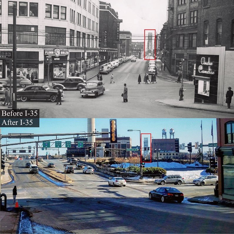
Because train tracks separated downtown from Canal Park long before the construction of I-35, I first thought that the before photo involved a perceptual trick and was taken much closer to the bridge than the after photo. But a photo on Minnesota Reflections shows how the street was kept level with traffic passing underneath at various points, creating a rather seamless integration of Canal Park and Downtown.
The older Twitter photo (and the one above) shows the Bradley Building on the left (demolished in 1979 for the construction of I-35) and Freimuth’s Department Store on the right (torn down in 1968). These two buildings used to be on opposite sides of Lake Avenue on Superior Street, so the two photos shown on Twitter are from the same location.
Of course the construction of I-35 through Duluth in the 1960s and ’70s was highly contested and the original plan would have made a considerably larger impact on downtown and the lakefront.
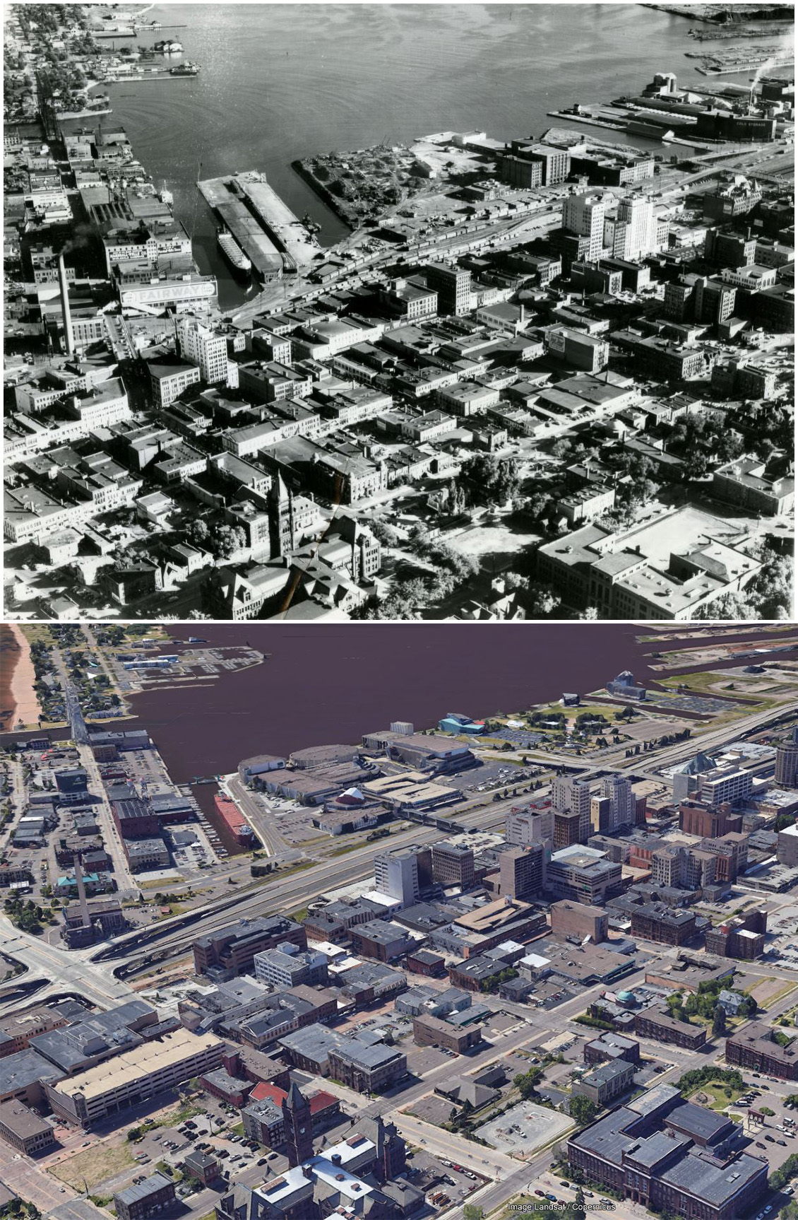
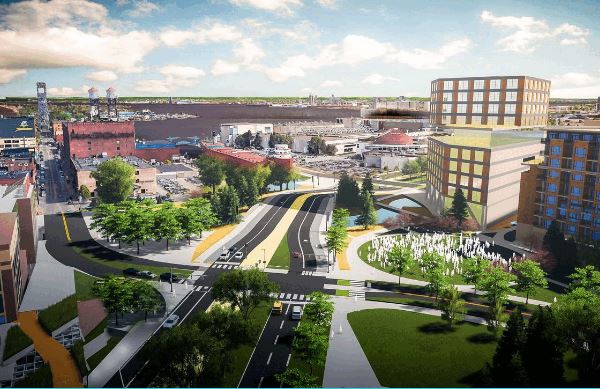
The image below compares an aerial photo of the location from around 1950 with a current Google Earth image from the same perspective, allowing you to evaluate on your own the degree to which cars destroyed Duluth.
Regardless of what happened in the past, if the plans of the Duluth Waterfront Collective are followed through on, perhaps by the time of PDD’s 40th birthday the After that we have now will have become the Before that we can hardly believe was once how things were.
I mean, your points are well taken. But is Duluth actually destroyed? All of it?
No, I would say that it is not. It’s not my Twitter account and I find that title a bit dramatic myself. If it were my account, I would have it only focus on Duluth examples and would give it this name:
Car infrastructure in its many forms is a necessary component of car accessibility and as the car is the preferred mode choice for most people in Duluth, most people in Duluth support the construction and maintenance of this infrastructure but car infrastructure is incredibly space intensive, its use comes with a number of negative externalities including air and noise pollution, and the need to mitigate the inherent dangers of cars for the people inside and outside of them requires such rigid design standards that meeting the expectation that every location will be fully accessible by car without any delay during travel or parking often results in the destruction of some of the very locations that one originally desired to easily access and can make the remaining locations, and many places along the way to those locations, significantly less desirable even for the people with cars and significantly less accessible for the people without them.
I’ll have to check on Twitter’s character limit for account titles.
Cars haven’t destroyed Duluth in the downtown area because the area where the freeway now stands was train yard and industry we don’t have today. Yes, it destroyed neighborhoods out west, and OK, sure, there are several buildings that no longer exist, but Duluth was already on a mission to remove all the Bowery areas in downtown (400 and 500 west blocks of Superior Street), and the Lake Avenue viaduct wasn’t really any better. (It’s not cars that destroyed downtown commerce in Duluth, but the mall.)
I don’t love the freeway placement, but if it wasn’t there, we’d probably have housing for rich people and No Trespassing signs, and wouldn’t even be able to see the lake.
In my opinion, the movement to undo the freeway would only screw up the commute (and push more traffic onto surface/neighborhood streets) and make space for more hotels.
Thanks for that concise summary of downtown development over the past century. I think it would be important to also include the impact of parking. Downtown could only accommodate a significant number of people driving by replacing stores, office and housing with parking lots and parking garages, an ongoing process that can be tracked through the countless Perfect Duluth Day posts about a building being torn down that end with “to be replaced by parking.” While this makes access by car continuously better, the trade-off is a pedestrian environment that becomes continuously less pleasant.
In addition to climate control and a sense of security, Miller Hill Mall provided the dense retail environment once found downtown AND easy access by car, a combination only possible by starting a new development removed from residential areas that allowed for large amounts of parking on every side.
While the mall may have had a greater impact on downtown than the construction of car infrastructure, it is kind of hard to separate the impact of the mall from the impact of the car. The mall retail model not only facilitates the use of a car but also only really works if you have one, just like the big box stores that populate the increasingly far reaches of Miller Trunk Highway. Not having a car would limit access to so much, it’s hard to even imagine not owning one. When nearly everyone owns a car, investments gravitate to the most car accessible areas.
With downtown having so many places in need of investment, a trade-off between a run-down building and a new parking lot doesn’t seem like much of a trade-off at all. And while giving up one old building for an additional parking lot really doesn’t make that much of an impact on the streetscape as a whole, repeating the process enough times can have an impact. Over time, it might even destroy a city.
The attached image is from 6th Ave East and therefore just outside of downtown but I think it provides some illustration. The top image is a current aerial image and the bottom is approximately the same area in 1939. While the bottom image is a bit blurry, if you look carefully in comparing the two, you can find a few spots that indicate how isolated choices to facilitate car access can result in an overall change to the general character of a neighborhood.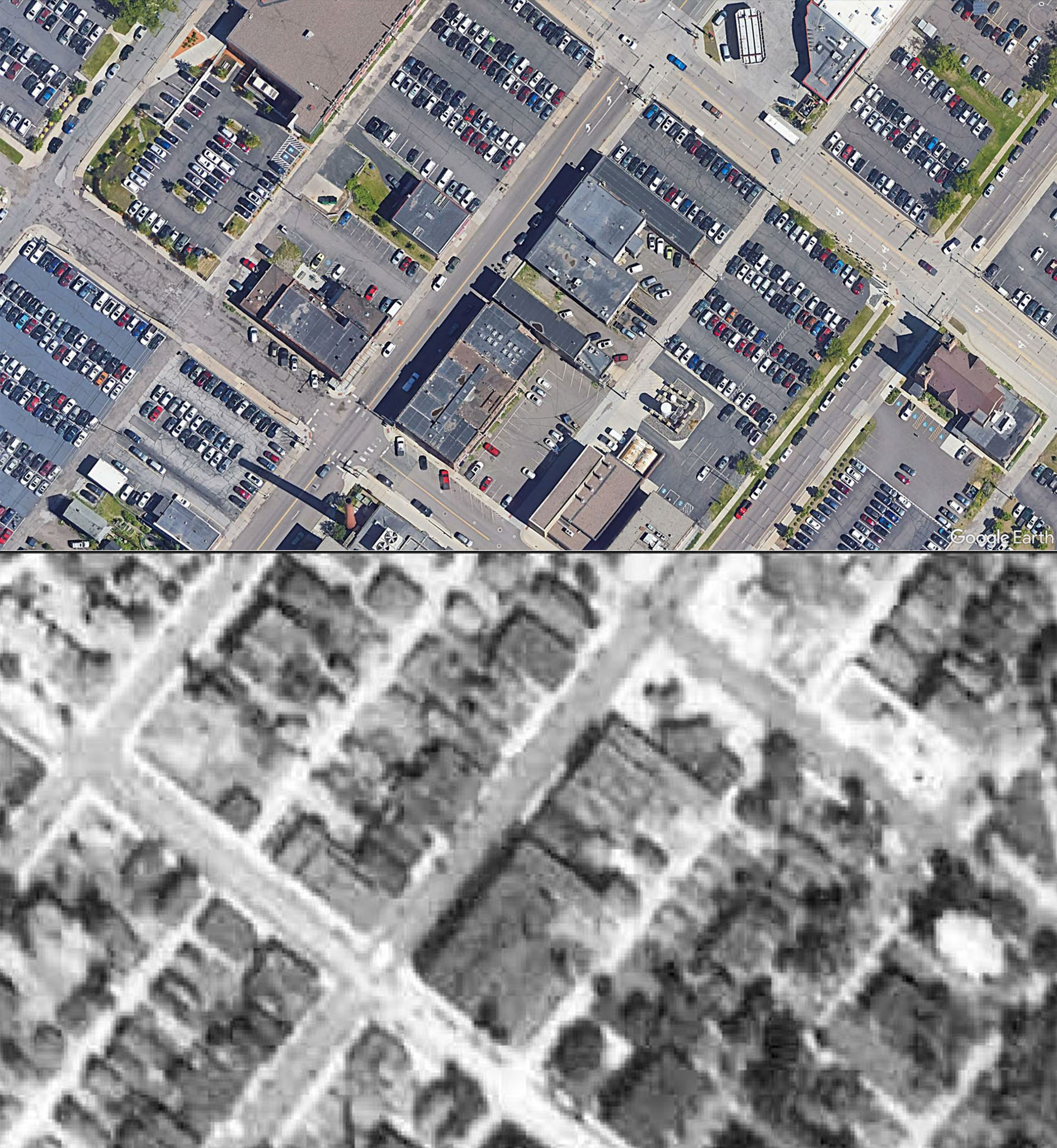
Ughhhhh. Good job Matthew James for that pic. Feedback loop over and over. I abhor the mall area and everything is moving toward that model of commerce/transport.
@Matthew James That picture is a great example. The 1939 imagery available from St. Louis County paints a stark picture of how much value we’ve traded for car infrastructure.
As you said, with enough repetition, surface parking (and improperly designed structured parking) can have a significant impact on streetscape quality. It gets far worse when structured parking facilities take up entire half blocks, creating “dead” areas of downtown that degrade public safety and make the walking experience poor. This creates a negative feedback loop for downtowns, destroying something of value (or potential value) for something that produces very little value, and in fact harms the overall fabric of the area.
What most people seem to forget is how land use directly impacts a city’s bottom line. How are the streets funded? How are the water and sewer systems funded? How do we fund the amenities we all value? What even is the purpose of a street?
Of course, the primary tool is property tax, levied on the homes and businesses in our city. Streets are the platforms for this wealth creation; that’s their primary purpose. When you artificially restrict the density of development on a street, you are reducing the amount of wealth you can generate from your infrastructure investment. Parking is a density destroyer. Restrictive zoning is a density destroyer. These are both things Duluth has far too much of, and big part of why we struggle to fund basic city services.
Dense mixed-use urban areas, such as our downtown provide huge value to a city. Downtown Duluth provides more property tax revenue per road mile that any other neighborhood in the city. More than Duluth Heights, more than Lakeside, more than Lincoln Park and Morgan Park. We should be doubling down on this value, making it the best neighborhood to live and work in as possible.
This means reprioritizing space (green space/trees/plazas instead of parking), encouraging and subsidizing office to residential conversions (where practical), setting on-street parking prices correctly to encourage turnover and increase use of existing structured parking, drastically improving winter snow removal efforts, and yes… de-emphasizing I-35 and extending the fabric of downtown to the waterfront and Canal Park.
The plethora of surface parking lots, particularly on East and West First Street, makes for an uninviting pedestrian experience and barren atmosphere; a vacuum of street life. If that’s what the writer intended by destruction then I would agree.