
How did the city of Cloquet get its name?
As mentioned in the “Northeastern Minnesota Nomenclature” post on Perfect Duluth Day last summer, the city of Cloquet gets its name from the Cloquet River. But how did the river get its name?
The subject was also touched on briefly last summer in the WDSE-TV documentary This Town.
“Who named that river is a bit of a mystery,” narrator Kevin Kling said. “Some believe fur traders named it after a pair of French scientists: the brothers Hippolyte Cloquet and Jules Germain Cloquet. Now, Hippolyte was a rhinologist — a nose doctor — and Jules was a surgeon, an artist and an inventor. We can only imagine which of those disciplines most impressed the fur traders.”
In December, Pine Knot News in Cloquet began delving into the topic for its “History Mystery” series. Perhaps we’ll never know, or perhaps we’ll finally find out.
In the meantime, here is what the rest of the internet has to say.
Wikipedia offers this:
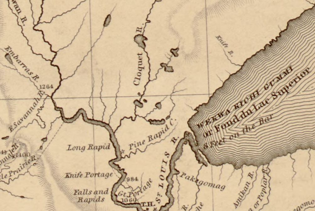
The word “Cloquet” first appeared on a map of the area by Joseph N. Nicollet in 1843 which named the Cloquet River, a tributary of the Saint Louis River, and the Cloquet Rapids to the north. “Cloquet” is a French surname but historians researching the name of the river and city have found no definitive answer, and are reduced to speculations. One of these is that the river might have been named after 19th century French scientists, the Cloquet brothers Hipployte and Jules, with the settlement later being named after the river.
The Carlton County Historical Society’s “Short History of Carlton County and the City of Cloquet,” on a somewhat broken page of the Cloquet Area Chamber of Commerce’s website, lays out a little background on the city without delving into where the name came from.
White settlement of the county began after the Ojibwe ceded the land of the area in the Treaty of 1854. Construction was begun on the Military Road which eventually connected Point Douglas, Minnesota (near St. Paul) with Superior, Wisconsin. The road passed through Carlton County and provided for mail delivery and passenger service. The coming of railroads to the county after 1870 allowed for the rapid growth of the timber industries and agriculture which form the base of the economic life of the area. The railroads have been largely replaced by a road system which includes a section of US I-35 which cuts across the county north and south.
The early building of the village that became Cloquet started in the form of several little settlements clustered around three early sawmills. These settlements were referred to locally as “Shaw Town,” “Nelson Town,” and later “Johnson Town.” More properly the whole settlement took its name from the most notable landmark in the region, Knife Falls, where the water flowed over sharp slate rocks that cut the moccasins of the voyagers.
The frontier site was platted in 1883, and in the following year, the three settlements were incorporated into the village of Cloquet. In 1904, Cloquet became a city with a mayor and common council form of government. The first mayor was Stokes Wilson. Many of the workers in the early industries and farming were immigrants from over a dozen European countries and Canada which, when mixed with the strong native culture, provided the rich cultural heritage still enjoyed by succeeding generations.
The Genealogy Trails website offers this:
CLOQUET (retaining the French pronunciation of its last syllable, as in bouquet and sobriquet), incorporated as a city, was named for the Cloquet river, from which, and from other tributaries of the St. Louis river, came the logs of its lumber manufacturing. The map of Long’s expedition, in 1823, shows that stream as Rapid river, and it is unnamed on the map by Thompson in 1826 for the proposed routes of the international boundary; but on Nicollet’s map, published in 1843, it has the present title, Cloquet river. It is not used outside of Minnesota as a geographic name, and here was probably derived from some fur trader. It is applied also to an island of the Mississippi in section 10, Dayton township, Hennepin county.
Good story. What map is depicted in the post graphic? Is that Nicolet (1843)?
Yes, it’s the Nicolet map, which is available in its full form for maximum geeking out on the Library of Congress website.
Link: Hydrographical basin of the upper Mississippi River from astronomical and barometrical observations, surveys, and information.