
River Walk West development seeks city land on trail in Riverside neighborhood
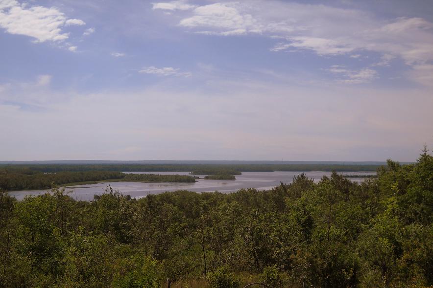
The view looking out to the St. Louis River from land the could become part of the River Walk West development.
On the Duluth City Council agenda for a first reading on July 12 is an ordinance authorizing the sale of city property in the upper Riverside neighborhood between Spirit Mountain and the U.S. Forestry Department’s Superior National Forest headquarters.
The buyer, Spirit Valley Land Co., plans to develop the area, which surrounds a popular Grant-in-Aid trail.
Also on the agenda for a first reading is an ordinance to convey additional upper Riverside property to the state to allow for its future sale to Spirit Valley Land.

Where exactly is this land? In the map above, Spirit Mountain’s ski runs are in the section with the green line around it. The blocks of land up for sale are marked in blue. That is, if this old map is still accurate.
To check it out in person, find where Gogebic Street intersects the trail, then go east. It’s a very nice area, with at least one spot that has a phenomenal view of St. Louis Bay, Clough Island and Spirit Island.

This little marmot likes it there.

The developers already own some land in the trail area, and also below Grand Avenue. From what I’ve been told, plans are vague at this time, but the front man for the development group, Brad Johnson, loves the outdoors and isn’t going to disturb the trail, but intends to put some tasteful log cabin town homes in the vicinity.
That being said, there doesn’t seem to be a lot of information available about this to the general public — what with city land involved — although various groups like the Spirit Valley Citizens & Neighborhood Development Association, the Riverside Community Center and Spirit Mountain board are aware of the plans.
So I’ll do my best to get some answers to as many questions as I can think of and update this post as I go.
1) Who are the people involved in this development? One name I’ve heard thrown around is hotelier David Goldberg. (He owns the Country Inn on Haines Road, the AmericInn in Proctor, and motels in Iowa and Michigan, as well as the manufactured home company Easy Housing and the manufactured-home communities Vintage Acres and Zenith Terrace.) Also involved are Pete Lukovsky and Mark and Keith Youngren, who own land in the area.
2) What will become of the frequently used Grant-in-Aid trail? According to the ordinance, the city is reserving “an easement for utility and trail purposes over, across and under the northerly 50 feet of the former Duluth, Winnipeg and Pacific Railway, as measured from the centerline of said rail line.” So, it sounds like the trail will stay, but it will have a little less woods and few more homes along it.
3) What about all the little foot trails out there? Will the general public still get to use them? Probably.
4) What did people have to say about this area during the comprehensive planning process and zoning code discussions? Did they feel, as is stated in the ordinance, that this land is “surplus to the city’s future needs”? Or is it valuable green space?
5) Has the city of Duluth really done anything since the Honking House debacle to make clear to its citizens what land is protected and what land is for sale? Should the media help sort this out a bit?
It’s good for the community to keep on these things. We may have been able to avoid some of the problems with Beacon Pointe and the lakewalk if the community was more involved from the start.
Good point Sam! Hopefully this developer realizes that the trail is something that could be a value added sales argument for his houses. Looking at his web site it does seem that he might have that thought, not sure but I really hope so.
I don’t think I’m familiar with that particular trail (although I’ve been on the SHT and other trails in that neck of the woods) but on a matter of principal I disapprove of the destruction of greenspace for more rich-people houses, no matter how “tasteful” the developers claim they will be. (Didn’t the Hoking House people originally claim that it would “blend into the landscape”?) Thanks for being a watchdog, Paul, and keep us updated if you hear anything else.
I of course meant “Honking House.” Although after I saw my typo I had to look up “hoke” in the dictionary, and that kind of works, too: “To alter or manipulate so as to give a deceptively or superficially improved quality.”
The developer is Brad Johnson from Chanhassen. He made a comprehensive proposal to the Parks & Rec Commission last August. After feedback and modifications, the Commission approved it to the extent it impacts park land. Planning and City Council may have other ideas.
About 1400′ of the Grant In Aid trail would become city street connecting to Gogebic. That’s reportedly at the Fire Department’s request for emergency access. The developer promises a 6′-8′ wide class 3 or 4 gravel trail near the new road for connectivity.
Mr. Johnson paid attention to our demands especially trail access. His proposal includes trails and connects to existing trails. I’ve got a pdf if I can figure out how to post it.
Keep paying attention to this. Every development has great maps and plans. Paying attention stops unpleasant surprises.
I had a short chat on the phone today with Brad Johnson, the front man of the development group, and hope to speak to him in greater detail later.
He confirmed that the trail would remain in basically the same spot and would be improved as part of the development.
“We’ve agreed that we’ll provide a Level III trail through there,” he said. “We’ve had the engineers look at how to do it and we’ve provided documentation showing where it would be. The agreements with the city are very specific that we have to complete this.”
He said his group has the right to relocate the trail within 50 feet of the centerline of the current trail, so apparently the trail couldn’t be moved very far.
“We’re granting back an equivalent of the trail easement all the way along there,” he said. “So there really is no change in the overall potential of that trail, it’s just that we’ve agreed to make the improvements. It’ll start at Spirit Mountain and end at Gogebic, which is about 3,200 feet.”
“If you go there now it’s washed away,” he said of the trail. “There are three major gullies that run through there. Unless you’re careful (on the trail) you could disappear.”
He’s right about that:
He said the new housing to be developed would be on the south side of the trail, not up the hill. An access road would be developed off of Gogebic, parallel to the trail.
Johnson noted there is no north-south connection between the Western Waterfront Trail, Munger Trail, Superior Hiking Trail and the Grant-in-Aid trail, and he hopes to establish that with the development.
“We came up with a complete trail connectivity plan for that whole area,” he said. “One of the keys to our long-term plan is that trails make the project. So we’re very concerned about that.”
He said a new trail would be created off the Western Waterfront Trail at Tallas Island, through the development, across Grand Avenue and up the hill to connect to the other trails.
Thanks for your attention to this Paul. I especially appreciate the proactive nature of your analysis. Sometimes retroactive bitching is sort of satisfying (honking house), but it doesn’t change much.
If River Walk West would indeed be on the south side of the trail and not too far up the hill the environmental impact may be tolerable. In general though, taking significant greenspace for development in a city with so many vacant or underutilized (but previously developed) parcels seems so unnecessary and counterproductive.
Please update those of us who can’t make tonight’s city council meeting. I look forward to learning more details and exploring the area first hand.
The council will introduce this ordinance July 12. It will either be voted on at the July 19 council meeting, or it will be tabled for a future meeting if the council isn’t satisfied with the amount of information available.
City Councilor Dan Hartman provided an answer for me on why the city is considering selling the parcels along the trail for $67,000 without an open bid:
“Typically the city goes through an open bid process to sell land. We have the legal option to do a direct sale. The reason for a direct sale versus an open bid is because there are many little sections to this trail and they are very small parcels individually. We could sell them off individually and maybe make more money, but then we wouldn’t know what the use would turn into. The city has a long-term value in the trail use.”
The city council unanimously passed both resolutions last night (July 19) — selling some land to the developers and reconveying some to the state. I wasn’t able to attend the meeting, and there isn’t a word about it in the daily newspaper, but Eyewitness News mentioned it.
Quoth news anchor Dennis Anderson:
“The city council did vote to approve the sale and exchange of land for a development at the bottom of Spirit Mountain. Spirit Valley Land Co. has a vision for about 80 acres of land that includes a ski lodge, multi-family housing, restaurants and walking trails. The council voted tonight to turn over 30 acres of that land, half of which will be sold with the understanding that the developer will put in a hiking trail for all to use. City Councilman Dan Hartman says aside from the 30 acres turned over tonight the rest of the land is privately owned. The developer could start building infrastructure as early as next year.”
And now the Duluth News Tribune reports:
Developers eye 80 acres below Spirit Mountain