Superior Hiking Trail Posts

Sixteen Years on the Superior Hiking Trail: Swamp River to Cascade River

Paul Lundgren Saturday EssayDigital cameras existed in the year 2000, but it wasn’t until about 2003 that using one became mainstream. I started my quest to complete the Superior Hiking Trail with a cheap 35mm pocket camera and a roll of black and white film … perfect for capturing lush fall colors. A grand total of four photos were taken during this five-day hiking trip.

By contrast, I have 35 photos and three videos from a five-minute window when I finished my hike in 2015. So the world has changed a bit. I worked for a newspaper then, I work for a website now. The World Trade Center buildings stood then, the National September 11 Memorial & Museum stands now. Time marches on at a faster pace than my hiking boots, apparently. My first trip covered nearly 60 miles of trail, however, and that’s not too shabby. Unfortunately, things slowed down after that.

On the sunny afternoon of Sept. 23, 2000, my friend Jeff and I drove the winding way of Highway 61 to Grand Portage. It’s not a place that is necessary or practical to go when seeking the start of the Superior Hiking Trail, but it’s a fun location to stop and look out over Lake Superior while there’s time to kill on the day before the adventure begins.

Sixteen Years on the Superior Hiking Trail: Introduction

Paul Lundgren Saturday EssayThe yearning for adventure is a pretty common human trait, along with the practical good sense to not get into a situation you can’t handle. The old Scout Motto is “be prepared,” a creed intended to make one think practically and plan ahead for potential disaster. There’s a colorful expression for those who are not ready for life’s misfortunes; they find themselves “up Shit Creek without a paddle.”

Not wanting to drift helplessly in liquid feces, people often put off serious adventure and plan to check their dreams off a “Bucket List” at some point between the impractical now and the day before it becomes physically impossible. When a Bucket List goes as planned, it’s a beautiful thing. More often than not, of course, it ends up being a list of unfulfilled wishes. That’s generally preferable to premature death in pursuit of pretty scenery, so lament accordingly.

There are also those perfect people in the primes of their lives, dressing up in expensive wingsuits and gliding majestically down from the world’s most spectacular cliffs. Are they the sons and daughters of the obscenely wealthy or did they persuade a gear manufacturer to sponsor them? Maybe both. Don’t be jealous. You probably wouldn’t take that leap if you could. I know I wouldn’t.

North Country Trail nears connection to Superior Hiking Trail

North Country Trail at MN and WI border

A new 4-mile section of the North Country National Scenic Trail, located 17 miles southwest of Superior, opens Saturday, bringing the trail another step closer to connecting to Minnesota’s Superior Hiking Trail.

The new segment crosses the University of Wisconsin-Superior’s MacQuarrie Wetlands in western Douglas County and features scenic overlooks of the Nemadji River Valley and the basin of Glacial Lake Duluth. It also crosses a section of Douglas County Forest and Wisconsin DNR lands.

Link to driving map

Fifteen-year journey on the Superior Hiking Trail complete

SHT VictoryThe champagne bottle popped shortly after noon today. In what must rank among the laziest accomplishments in endurance sports history, I completed the final stretch of my quest to hike the entire Superior Hiking Trail … 15 years after I started.

The 296-mile journey was tackled in about 45 different hikes spread out between Sept. 24, 2000, and Oct. 11, 2015. The longest single hike was about 15 miles. The shortest was today’s hike, which was less than a mile. Perhaps some day I’ll gather stories from the journey into some sort of narrative, but for today I’ll just present a simple breakdown of the mileage per year.

Video Archive: Paul Hlina on the Superior Hiking Trail in 1995

With a fused spine and partially paralyzed legs, Paul Hlina hiked the entire Superior Hiking Trail on crutches in 1995. He is credited as the first person to through-hike the trail, which at the time spanned almost 200 miles. It’s about a 300-mile trail today.

Beginner’s Guide to Backpacking on the Superior Hiking Trail

Greg Poulton and Logan Faulkingham, experiential education students at Minnesota State University, Mankato, provide advice for people new to backpacking who would like to take a trip on the Superior Hiking Trail. It features tips and tricks for menu planning, equipment selection, packing and cooking, plus footage of the fall colors, waterfalls, Lake Superior and a little wildlife.

Will Duluth see more mansions on the hill?

Skyline Parkway - Richard A. Peterson Trust Land

It’s been five years since William Agenter built his high-profile home on Skyline Parkway. Although the mansion on Duluth’s western hillside was built legally on private land, some saw it as an intrusion on an otherwise woodsy section of the scenic drive perceived to belong to the public.

That controversy has come and gone, but another could be looming. Across Skyline from Agenter’s property sits 43.7 acres of wooded hillside, adjacent to popular hiking and biking trails, marked with Lynn Beechler Realty signs. Sale of that land to someone eager to develop more housing with expansive views of the city could happen any day, though the buyer would face challenges.

Fall Colors on the Brule River at Judge C. R. Magney State Park

Brule River at C. R. Magney State Park

Lost Benchmaker Knife on Superior Hiking Trail

I lost a blue Benchmade pocket knife just off of the parking lot on the Superior Hiking Trail at Penn Boulevard in Silver Bay on Aug. 29. I believe it was on the four-wheeler trail just before hooking up to the hiking trail. Will pay reward and shipping to get it back.

Stone-Arch Bridge and Haines Road open

stewart-creek-bridge

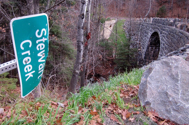
The Stewart Creek Stone-Arch Bridge at Magney-Snively Natural Area (State Bridge Number L6007; built circa 1925) has been repaired from damage sustained during the Hideous Solstice Flood Calamity of 2012. The bridge had sustained significant flood damage and deterioration to the abutment walls, stone-arch underside, headwalls, wing walls, railing and guard stones. (We’re not sure when that sign was damaged or when it will be pulled upright.)

Probably the last Superior Hiking Trail post of 2013 … but we’ll see

I’m not sure if this is called Fox Farm Pond or Paisley Pond or both, but it’s funky as hell.

Superior Hiking Trail: Martin Road to Lismore Road

There hasn’t been a lot of hype surrounding it, but as of June 1 the Superior Hiking Trail is complete from Duluth to Two Harbors. The missing link is no longer missing. You can now hike the trail from Jay Cooke State Park to the Canadian border … you know, if you feel like a nice 296-mile trek.

Above is the starting point of the Duluth to Two Harbors section, from the trailhead at Martin Road on the Duluth / Rice Lake Township border. The start of this section is cut on the old North Shore State Trail, and a sign there pays tribute to C. J. Ramstad, “Mr. Snowmobiling.”

Minnesota Fall Colors 2012 — From Castle Danger to Split Rock State Park

Minnesota-Fall-Colors-11

Pics from the Superior Hiking Trail.

Superior Hiking Trail – Top Ten Spots

Below is a nice video by http://superior-hiking-trail.com showing 10 spots along the Superior hiking trial they enjoyed the best. Learn more about the Superior Hiking Trialwww.shta.org

What are some of your favorite spots along the North Shore of Lake Superior (a.k.a Big Sexy)?

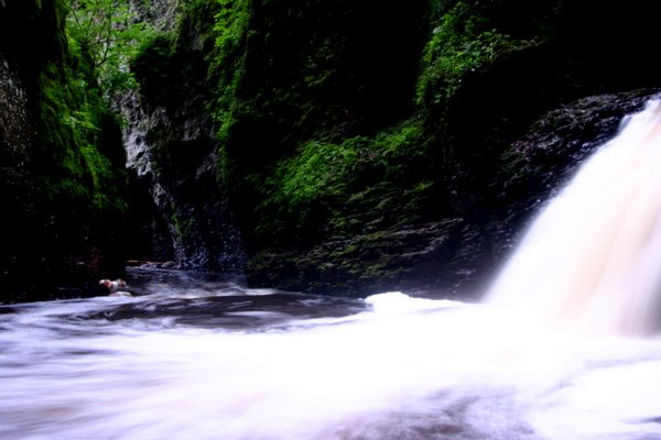
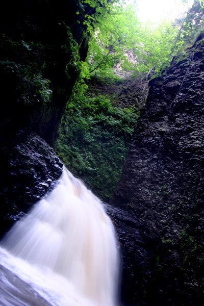
One of mine is the Kadunce River falls, the only way to access the base of either falls is to hike up river into the canyon.

Fall colors on Lake Superior’s North Shore: Silver Bay and Beaver Bay area

PennCreek894572

Someone left this for me to find on the footbridge across Penn Creek. Kudos to the artist.

Do NOT follow this link or you will be banned from the site!