Mystery Photo #101: Forest Service Office at Grand Marais
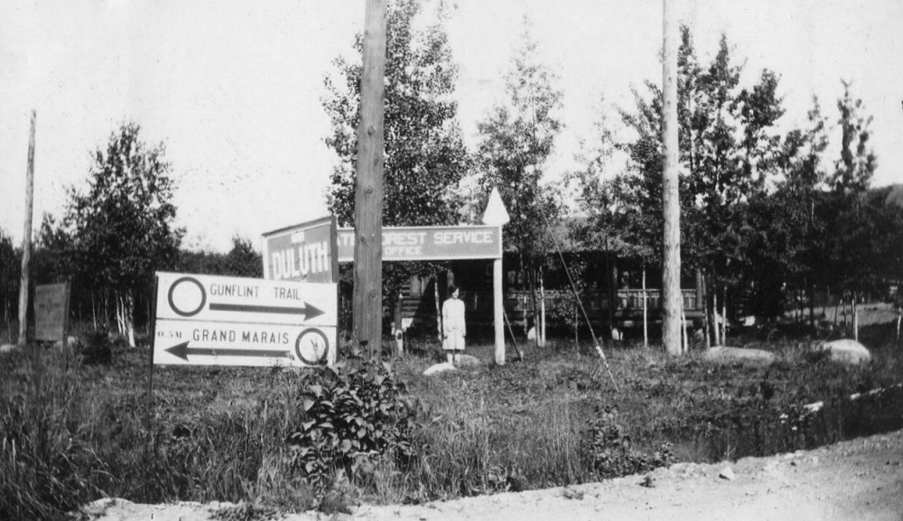
This photo seems to be of a forest service office on the southern part of Cook County Road 12, aka the Gunflint Trail, in or near Grand Marais. Or does it show a private residence and the arrow on the forest service sign indicates the office is up the road? Who is the gal posing the photo? What year is was this picture taken? Mysteries abound.
This seems like a particularly mysterious mystery photo because it contains an over-abundance of clues that don’t immediately lead anywhere definitive. But because there is nothing yet posted here, I’ll try to provide a possibly reasonable guess: The photo was taken just north of the intersection of Fifth Avenue West and Second Street in Grand Marais.
This is based on not much other than trusting the information provided in the photo itself and using a 1942 plat map and a 1957 tourist map to interpret it.
The Sawtooth Mountains appear to be visible through the trees, which means the photo is taken facing north.
One of the arrows suggests that the photo is taken on the Gunflint Trail itself, which, according to the 1957 map, originally ran up Fifth Avenue West in Grand Marais.
The wooden electricity poles and the sign on the far left side of the photo suggest the picture was taken near an intersection, but which Fifth Avenue intersection isn’t clear.
The Grand Marais sign implies that the city itself is a half-mile to the south. So the cross street would be half a mile north of Grand Marais on Fifth Avenue. The accuracy of the half-mile measurement and where Grand Marais would be considered beginning at that time is not entirely clear, but the 1942 map does suggest an answer. Grand Marais’ streets, while now numbered, used to be named after northern cities and Second Street was originally Duluth Avenue. The sign that says Duluth, therefore, may not point to the city of Perfect Duluth Day but rather identify the name of the avenue on which it lies. While Second Street is closer than half a mile to Highway 61, the intersection itself is exactly a half a mile from Broadway and Wisconsin Street, which seems to have been the center of the Grand Marais commercial district around that time.
The sign perpendicular to “Duluth” names the U.S. Forest Service office and appears to be topped with an arrow. The 1942 plat map shows the forest service office as being just south of Highway 61 between Fifth and Sixth avenues west. Following that arrow south would lead you there.
None of this proves that intersection is the location of the photo, but it may be the only location that aligns with everything in the photo.