After a ridiculously warm weekend, it seems like spring has arrived early. Before you know it, thousands of Minneapolis-types like myself will be driving up Interstate 35 to the cool shores of Gitche Gumee.
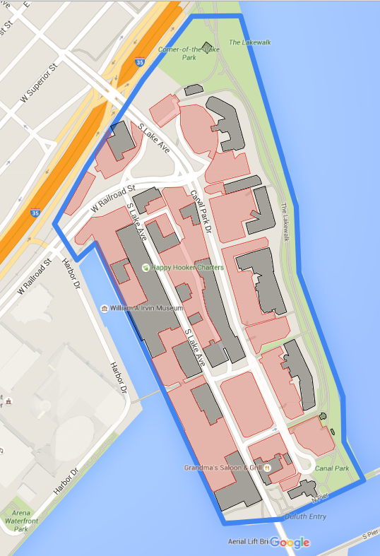
Since its post-industrial low point a few decades ago, Duluth has built Canal Park into one of the top-drawing tourist spots in the state. It’s definitely a great place, but I continue to be amazed by how much prime Canal Park real estate is occupied by pavement for storing cars. After a visit last fall, I made this map and found there are 21 acres of surface parking in Canal Park.
The blue boundary is the core 67.8-acre area I studied, bound by the big lake, the ship canal, Minnesota Slip, and the Interstate 35/railroad corridor. The black boxes are structures of any kind, and the red boxes are surface parking lots.
Structures occupy 19.12 percent of Canal Park’s land area. Surface parking occupies 31.05 percent.
It would be extremely difficult to apportion the remaining half of Canal Park that’s not structure or surface parking, but I’d approximate that the balance of the land is split roughly into thirds: One third public streets and roads, one third public parks (including the Lakewalk and the actual Canal Park), and the final third as Non-Place Greenspace.
Originally posted at streets.mn with CC by-nc-nd.