Hiking Posts

A Guide to Hiking Tischer Creek

Stone-Arch Bridge and Haines Road open

stewart-creek-bridge

The Stewart Creek Stone-Arch Bridge at Magney-Snively Natural Area (State Bridge Number L6007; built circa 1925) has been repaired from damage sustained during the Hideous Solstice Flood Calamity of 2012. The bridge had sustained significant flood damage and deterioration to the abutment walls, stone-arch underside, headwalls, wing walls, railing and guard stones. (We’re not sure when that sign was damaged or when it will be pulled upright.)

Probably the last Superior Hiking Trail post of 2013 … but we’ll see

I’m not sure if this is called Fox Farm Pond or Paisley Pond or both, but it’s funky as hell.

Superior Hiking Trail: Martin Road to Lismore Road

There hasn’t been a lot of hype surrounding it, but as of June 1 the Superior Hiking Trail is complete from Duluth to Two Harbors. The missing link is no longer missing. You can now hike the trail from Jay Cooke State Park to the Canadian border … you know, if you feel like a nice 296-mile trek.

Above is the starting point of the Duluth to Two Harbors section, from the trailhead at Martin Road on the Duluth / Rice Lake Township border. The start of this section is cut on the old North Shore State Trail, and a sign there pays tribute to C. J. Ramstad, “Mr. Snowmobiling.”

The St. Louis River Trail

A few weeks ago I was in Chambers Grove Park in far western Duluth when I saw a sign in the corner of the park for the St. Louis River Trail. A few days ago my wife and I returned to investigate it. After hiking a portion of the “trail” it seems that it is not maintained and I can’t find any information about it on the internet.

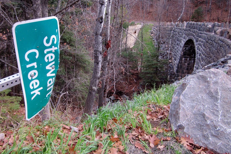
Anyone out there know about it? Is it even an official trail or did some guy just put the sign up? Is it merely in the planning stages? Whose property does the trail lie on? Minnesota Power’s? All I can say is that the walking was pleasant. Most of the “trail” followed an old rail line and there were many utility poles that had been cut down along the corridor. There is also the remains of an old railroad trestle at the point where we turned around.

If anyone has any more information about the St. Louis River Trail, it would be appreciated by this hiking enthusiast. I put a more detailed trip report up here:

The Continuing Adventures of Eric and Noelle
The St. Louis River Trail

Fall colors on Lake Superior’s North Shore: Silver Bay and Beaver Bay area

PennCreek894572

Someone left this for me to find on the footbridge across Penn Creek. Kudos to the artist.

Do NOT follow this link or you will be banned from the site!