Mystery Photo #64: Edge of Unknown Lake

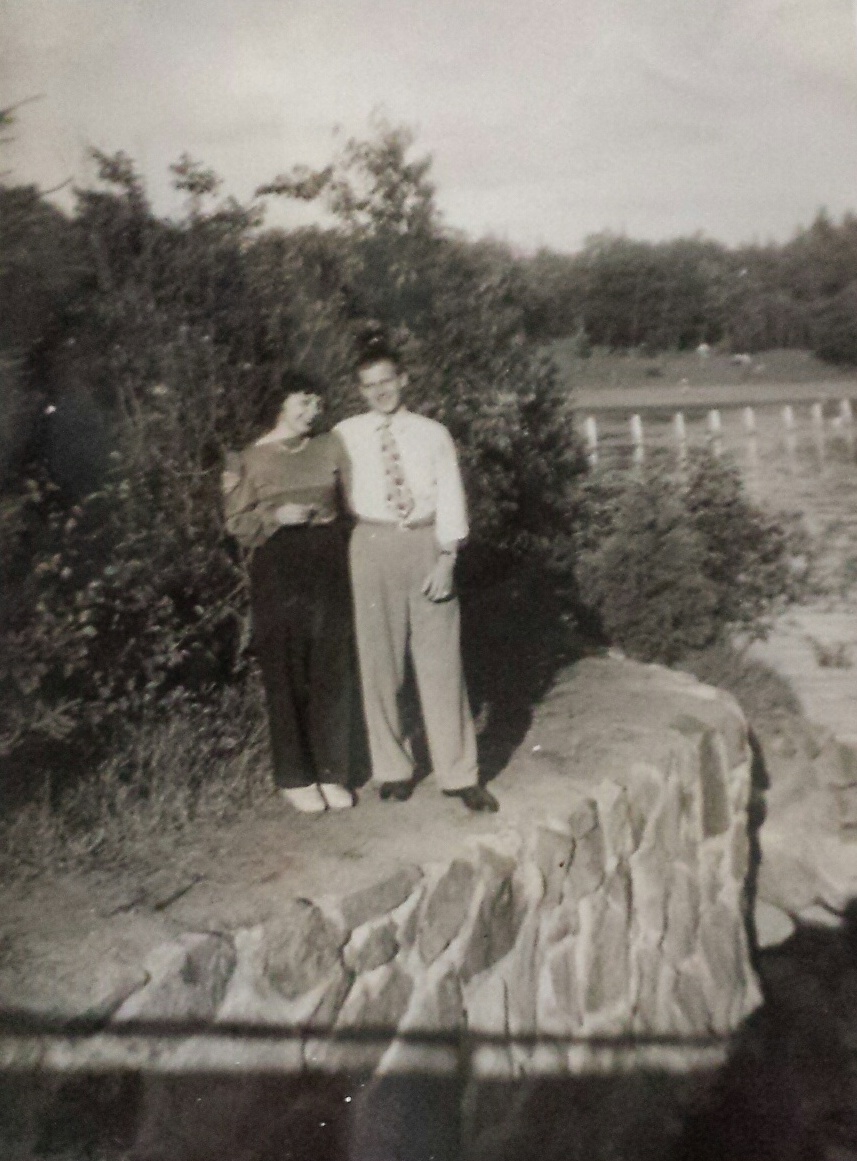
This photo comes to us from Les Locklear, who has that feeling we all get from time to time. You know you recognize something, but you just can’t place it.

“I know I’ve been there and it’s familiar, but I haven’t been in Duluth since 1972,” Locklear writes. “This photo is of my Mom, Gloria (Irwick) Nelson and my Dad Lester Nelson. He was from Superior, so it might be from there. She never dated photos until I was born (October 1943) so I’m guessing it might have been 1942.”

So we know the who and the vaguely when. Where are ol’ Gloria and Lester standing?

6 Comments

Paul Lundgren

about 6 years ago

Two guesses sent my way so far:

1) Twin Ponds. That shadow across the bottom does look a bit like a bridge, similar to the bridge that dissects Twin Ponds, but that stone wall the couple is standing on doesn't look like anything at the modern-day Twin Ponds.

2) The "dam where the Black River exits the lake by the swimming beach at Pattison State Park south of Superior" seems like a better bet. That certainly looks like a good match on Google Maps, although it's not clear if the stone wall is there or not. Maybe it was removed at some point. The shadow of a bridge in the old photo could be from East County Road B.
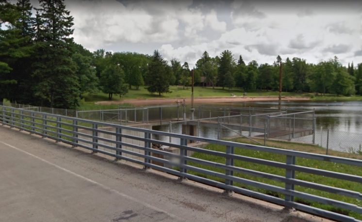
rev

about 6 years ago

Huh! I was also thinking of the beach/dam area of Pattison State Park. No clue what the place was like in the 40s, though.

Ramos

about 6 years ago

I'll guess Chester Bowl. Here's a picture of a kid swimming at Chester Bowl in the past.

Les Locklear

about 6 years ago

Growing up in the 1940s and '50s we spent a lot of time at Pattison Park in the summer swimming and family picnics. I would think that's probably it. 

Thanks to all of you!

Matthijs

about 6 years ago

This mystery seems pretty well solved and closed, but I thought I’d add in a couple extra details for no other reason than to move the “probably” status of Pattison State Park up to “a most likely.” Maybe even an “almost certainly.” 

As noted in Paul’s comment, Google Streetview and satellite imagery seem to show pretty clearly that there is no stone wall where the lake and the river meet. Pattison State Park, however, was constructed by the Civilian Conservation Corps, and a history of that project provides a description of the rock walls that used to be at the exact location suggested:

Another big project was the removal of the bridge abutments and road grade left when the State Highway 35 bridge over the Black River was moved in 1932. Concrete abutments were demolished, the old grade was leveled, and landscaping and tree planting done. In addition, the river banks both below and above the bridge were protected from erosion by rock walls. Stones weighing as much as 600 pounds were hand maneuvered into place.
The photo also shows vertical barriers around the swimming area that don’t seem to be a part of the beach area of the state park. But they can be seen clearly in a photo dating from the construction of the beach (from the same CCC history) and in an old postcard of the beach. While that doesn’t conclusively prove that it is Pattison State Park, it seems to remove any reason to believe that it isn’t, particularly in the context of Locklear’s family history there.  

Les Locklear

about 6 years ago

That is some serious internet sleuthing. I showed the photo to an older cousin on my Fathers side of the family and he said he recognized it as being at Pattison Park. We would spend the day there and then go to one of the family's cabins at Lake Nebagamon.

Many thanks for your efforts!

Leave a Comment

Only registered members can post a comment , Login / Register Here

Do NOT follow this link or you will be banned from the site!
Read previous post:
Naming the Problem

In a downtown tourist shop, my daughter Claire admires a sparkly jacket. It’s gold with embellishments on the shoulders. She...

Close