
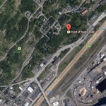
Duluth’s Point of Rocks

The main personality split in Duluth occurs about where an interfering spine of rocks comes down from the hill to Superior Street just a few blocks west of midtown. West of this point of rocks Duluth is politically left, east of it it is politically right. But there is a certain uniting force in cold weather, of which Duluth has its share.
–From “Duluth,” an essay by Arthur W. Baum
in the April 16, 1949, Saturday Evening Post
The Peerless Auto Body Fire post on PDD sparked some discussion of the former Peerless location near Point of Rocks, which led to some interest in the history of Point of Rocks.
So, here we go …
From Zenith: A Postcard Perspective of Historic Duluth, by Tony Dierckins:
Since 1887 Duluthians have been chipping away at Point of Rocks, a giant rock outcropping near Thirteenth Avenue West and Superior Street.
Early attempts to remove the stone were spurred both by safety concerns and in order to make Superior Street straight. Shortly after the first blast in 1887, a huge boulder narrowly missed a man on horseback. In 1924 a movement grew to remove the natural landmark after 100,000 tons of rock fell onto Superior Street (another 100,000 tons fell in 1931 after heavy rains).
Duluthians found a use for the Point: both painted and handbill advertisements found their way onto the stone, as the postcards at left attest. In 1919, city leaders decided to turn Point of Rocks into a work of art. They brought in Mount Rushmore sculptor Gutzon Borglum to blast the rock into the form of the city’s namesake, Daniel Greysolon Sieur du Lhut. But Borglum found the stone too hard to carve and refused the job. (A bronze statue of du Lhut by famed sculptor Jacque Lipschitz stands in UMD’s Ordean Court.) Despite blasting and plans for public art, Point of Rocks remains-albeit smaller-and Superior Street still bows around it.
Here’s an old postcard view:

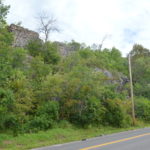
Below is a modern-day shot that includes (I’m pretty sure) the same rock. (It’s hard to tell, the area has been blasted so many times over the years.)

Here’s a story from the Feb. 15, 1902, Duluth News Tribune:

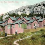
And here’s two photos from the X-Communication archives of the houses that made up the Little Italy neighborhood at Point of Rocks known as “The Glenn,” circa 1887.


Quoting Tony Dierckins:
Duluth’s Southern Italians, many of whom worked the railroad yards and coal docks, settled below Point of Rocks in an area also known as the Glenn. Prior to the Italians, this had been a French settlement. Most of the homes, built not along streets but on the hillside tucked within the rocks, were little more than shanties.
The ramshackle housing of the Glenn was dismantled and its streets were realigned. Ruins of foundations can still be found. The ruins of Duluth’s first water reservoir, which operated from 1883 to 1899, can still be seen rising from the hill above First Street between Tenth and Eleventh avenues west.
An article on street improvements in the Oct. 28, 1888 Duluth News Tribune notes:
Down by the point of rocks one may see the really colossal work. When a mountain gets in the way of a Duluth street it is hard on the mountain. The rock cut on West Michigan Street is well worth seeing, but the street that will result will be prettier to look at. They can no longer compare Duluth to a pair of saddlebags.
In the 1890s, Point of Rocks was mined for silver by the Duluth Silver and Copper Mining Co. They blasted a 300-foot tunnel into the rocks, spending $200,000 to extract $70,000 worth of silver.
In the early 1900s, the city crushed rock there for building materials. Here’s a modern photo from the top of what clearly appears to be an old quarry.

In 1998, boulders fell from Point of Rocks onto the sidewalk at Mesaba Avenue. An excavation company was later brought in to ignite explosives and remove several giant chunks of rock deemed hazardous.
Leave a Comment
Only registered members can post a comment , Login / Register Here


46 Comments
tom
about 13 years agoPaul Lundgren
about 13 years agoDefining exactly what Point of Rocks is might be tricky, since there are several points, if one chooses to look at it that way. (I should also note that, although it's almost always referred to as Point of Rocks these days, older references render it in the singular -- Point of Rock.) I believe Whoopee Wall is a section of Point of Rocks, although it is a bit west of the walls of rock in the images above. How or when Whoopee Wall got its name, I don't know, but it almost certainly comes from rock climbers who use it for its class-5 climbs. Whoopee Wall is on Piedmont Avenue, between Superior and First streets.
rs
about 13 years agoPaul Lundgren
about 13 years agosamh
about 13 years agoDave P
about 13 years agoCory
about 13 years agoDave P
about 13 years agoPaul Lundgren
about 13 years agoPaul Lundgren
about 13 years agosamh
about 13 years agoyear of glad
about 13 years agoPaul Lundgren
about 13 years agoyear of glad
about 13 years agoPaul Lundgren
about 13 years agoSpy1
about 13 years agoPaul Lundgren
about 13 years agoFrom May 10, 1910:
Paul Lundgren
about 13 years agoPaul Lundgren
about 13 years agoPaul Lundgren
about 13 years agoFrom April 30, 1918:
wildgoose
about 13 years agoSlapShot
about 13 years agoPaul Lundgren
about 13 years agoPaul Lundgren
about 13 years agoDuluth News Tribune opinion from Aug. 2, 1912:
Claire
about 13 years agoBad Cat!
about 13 years agoRick Aylsworth
about 13 years agoRacist Heir
about 13 years agoPaul Lundgren
about 13 years agoI'm not including the full text of this article from Aug. 6, 1916, because it's difficult to read and the headline pretty much tells the whole story.
Paul Lundgren
about 13 years agoHere's a fuzzy 1917 photo of a rock crusher from Point of Rocks. The Duluth News Tribune caption reads: "Commissioner Farrell plans to remove the city rock crusher from the Point of Rocks, where it has been in use for several years, to another part of the city. The crusher, it is understood, will be replaced shortly by one with a larger capacity."
David
about 13 years agoPaul Lundgren
about 13 years agoPaul Lundgren
about 13 years agoIn 1917, Victor Dash had an interesting suggestion.
adam
about 13 years agoPaul Lundgren
about 12 years agoPaul Lundgren
about 12 years agoPaul Lundgren
about 12 years agoSept. 25, 1918:
Paul Lundgren
about 12 years agoOl' John Fredin had his share of trouble with the rocks in 1913.
Paul Lundgren
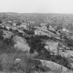
about 12 years agoHere's a 1913 panorama from Point of Rocks. (Click to see it larger.)
Paul Lundgren
about 12 years agoOct. 7, 1916:
Paul Lundgren
about 12 years agoPaul Lundgren
about 12 years agowildgoose
about 12 years agoThere is an awesome quote referring to Paul Lundgren as "president" of PDD. Herewith, I think you need to update your PDD name to reflect that honorific.
wildgoose
about 12 years agoPaul Lundgren
about 11 years agoKathie
about 6 years ago