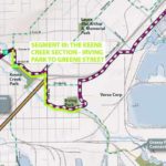
Perfect Duluth Day | Duluth MN Blog, Events, News and More


RECENT COMMENTS

    You have more unread comments...


  • CATEGORIES

  • ARCHIVES

Cross City Trail: The Middle Part

In a Feb. 18 post the maps for the proposed Cross City Trail — which will connect the Munger Trail to the Lakewalk — were laid out. In the comments I included photos of the various route options for the westernmost section.

The middle section of the trail — from Ramsey Street to Clyde Park — has only one option, so there’s not a lot to seek feedback on, but I thought I’d shoot some photos anyway.

This bridge is actually NOT part of the proposed trail; I just like that a tree is growing through it.

Before beginning the photo tour, here are the links to the maps that are pertinent to this section:

Ramsey Street to 40th Avenue West area
40th Avenue West to 29th Avenue West area

So, crossing Mike Colalillo Drive at the bottom of Ramsey Street and heading under the freeway you’ll see a little bridge that looks like this:

Cross the bridge and you’re on your way. This next shot isn’t from the trail; it’s for perspective. The trail runs near the utility polls.

At 40th Avenue West, the trail goes along Oneota Street briefly. Below is the view from there, looking back.

When you get to 37-1/2 Ave. W., take the little bridge over I-35. Look! You have a lovely view of the Honking House!

Turn right on Michigan Street and the trail will climb a small hill to Wade Stadium — home of the Duluth Huskies.

Then you cross over Michigan Street on this snappy little bridge.

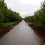
Follow the trail under the ore docks, and then under I-35. Maybe you’ll see a shiny red train.

This ain’t no nature trail, it’s about connecting to a nature trail through some heavy industry.

We conclude this tour of the middle section of the trail at Clyde Park and the Duluth Heritage Sports Center.

12 Comment(s)

  1. This’d actually be cool if after they link it to the Munger, they found a route to continue it on down toward the cities, which has an immense network of hiking and biking trails linking Minneapolis, St. Paul and the burbs.

    It does sound like a project along the magnitude of the luce line trail.

    Hook all that up with the Superior Hiking Trail and parallel running North Shore state trail and you’ve got a human-powered system that could rival the AT.

    This system could eventually become the fourth jewel in the crown, but is it possible to have a “Quadruple Crown?”

    zra | Mar 1, 2010 | New Comment
  2. Heck yeah.

    We could also have single track Mountain Bike Trails that weave in and out of that system as well … in fact throughout the whole city. You could ride east to west on natural surface trails then take the city bus home!

    Good work Paul way to put the route into perspective.

    Loki | Mar 1, 2010 | New Comment
  3. The way CN keeps its engines, the chances of spotting a shiny one are slim. Nice find.

    udarnik | Mar 1, 2010 | New Comment
  4. ‘And a tree runs through it’ … There’s a metaphor in the raw beauty of your photo but can’t quite define it.

    Is it a birch tree or just a wayward willow? Talk about surviving in spite of … either way, a great bit of exploration of too seldom, unexplored landscape. Thanks.

    beryl k gullsgate | Mar 1, 2010 | New Comment
  5. Just to make sure a little street gets its due… doesn’t the snappy little bridge near Wade Stadium cross Jenswold Street, not Michigan?

    akjuneau | Mar 1, 2010 | New Comment
  6. According to Google Maps, that little section the bridge crosses over is West First Street. It’s where West Michigan Street connects with West Superior Street.

    But according to Rand McNally, Michigan Street ends at 40th Ave. W. and Jenswold is the street behind Wade Stadium.

    But the street sign across the bridge on 37-1/2 Avenue West (in the photo above) refers to that street as Michigan Street.

    So I guess it’s a mystery. And akjuneau, I know you love a good mystery.

    Paul Lundgren | Mar 1, 2010 | New Comment
  7. I saw a sinister guy with a waxed black mustache planting that tree on the train tracks a few years ago.

    Ramos | Mar 1, 2010 | New Comment
  8. Thanks again for the photos, Paul. As a pedestrian/cyclist, I’m really excited about having this trail that links up most of the city. I think it’ll be really good for the Clyde Park project to have trail access -- at least, I know I’m a lot more likely to go there if I know there’s a safe bike route. It’s not a nature trail, no, but it looks like there’s enough buffer space along the trial to plant some spruce or aspen or sumac to gussy it up a bit.

    Sonya | Mar 1, 2010 | New Comment
  9. Thanks Paul, pictures really help. I will support this project. Not trying to do a one up but it would be way cool to have Todd Gremmels take his model airplane with the camera and do an aerial video of the route. Our own little drone.

    frank nichols | Mar 1, 2010 | New Comment
  10. @frank -- are you calling Todd Gremmels a little drone?

    rnarum | Mar 1, 2010 | New Comment
  11. Looking back I see what you mean, I’ll have to think about that, probably wouldn’t be a bad thing.

    frank nichols | Mar 1, 2010 | New Comment
  12. Paul,

    I’d love to see a pdd hike from Enger to points westward. It would be the SHT.

    mevdev | Mar 2, 2010 | New Comment

Post a Comment
Subscribe To Comments RSS

You must be logged in to post a comment.