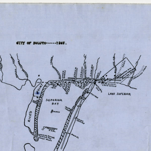
Interesting, if you zoom in on the map there's a Luce's Dock office not far from where Pizza Luce is now. Also "Indian Graves" on Park Point. I wonder what happened to those?
It's all explained in my book on the bridge (the title of which I won't mention, lest I get flamed for shameless self promotion), which includes a "new" map based on the map you've posted, which was likely drawn by Customs House employee Charles Johnson, who also drew those famous early sketches of the first wooden bridge over the canal.

There's more to the map, which goes west past Oneota. Luce's Dock Office belonged to Sidney Luce, Duluth pioneer and one of its early mayors. It was at roughly Third Avenue East on the lake, closer to Carmody than Luce.

Ojibwe and Dakota before them lived on Minnesota Point, and some Ojbwe stayed quite a while once it became Duluth. There were actually several grave sites (the map shows another on Rice's Point), at least one of which exposed its bones and artifacts after a storm. (Sorry, I don't have the dates handy.)
For continued native burial zones see the end of Moccasin Mike Road on Wisconsin Point. The burials there were dug up and moved to a "proper" graveyard at a church in Superior.
I have always heard people reference Minnesota Point (Park Point) as being man made. When really it was a natural sand bar, one of the longest freshwater sand bars in the world. As seen on your map native Americans inhabited it via a small portage. Pretty sure the native Americans didn't decide to build a 10 mile sand bar. I think the confusion is that some people consider it an island because of the canal. So really Minnesota Point became a man made island when the canal was dug out in 1870.
A few more details on Portland, since it's something I've been working on:

The townsite was settled in 1855, platted in 1856 by owners Aaron B. Robbins, James D. Ray, C. Marshall and J.J. Post, incorporated as a village on May 19, 1857, joined with Duluth on March 30, 1861.

According to the MacDonald book (This is Duluth, which was written in the 1950s): "In 1854, John I. Post built a cabin on the site of the present market on Second Ave. E between Second and Third Streets. He named this location Portland." There was also a school there in 1859.

Portland Square is, as far as I can tell, the oldest park in the city. It was already an official park in 1888 when the Parks Commission formed a number of the others.
The Town of Portland was platted running true north/south unlike Duluth's current northeast/southwest layout. Washington Avenue was the main street and it used to run right across Portland Square diagonally. There is a tiny remnant of it at the bottom of 7th Ave E.

My house in Chester Park is listed as being in the Portland Division of the City of Duluth.
I believe the aforementioned Oneota also was laid out on a true NSEW plan. If you look at a map, you'll see that the avenues in West Duluth still run true north/south, while the streets are true east/west. Northeast of Central Avenue, they change to Duluth's more familiar NE/SW layout.
This map was included with the title and abstract when we bought our house. It shows the streets before they were changed to numbered names. Based on the description of our lot #, looks like 18th Ave E was Ohio, 19th was Indiana, 20th was Missouri and so on. And Woodland wasn't there.

Here's a link to a bigger version


I don't know what the date of this map was, the house was built in 1909, and there's stuff in this title and abstract folder with dates from the 1850's. Originals, not copies. Seems like someone other than me should be holding onto them.
Ah, the Swansonian institute! Eric is exactly right. And when they replatted Portland to follow the rest of the city, the removal of Washington turned Portland Square into what many consider Duluth's first park (Cascade also holds the claim).

Barrett, I think you're right as well, especially if the 1865 map is any indication. You can see my modern reinterpretation of that map here (http://www.x-communication.org/xcomm/books/crossingthecanal_PDDMAPspecial.html), which has other interesting details, such as "Meander Island," 2.4 acres of floating vegetation in what was then called Superior Bay. By 1870 there was another township called "Fremont" near where the DECC is, which was all very swampy. After a storm in May 1873, a large chunk of Fremont actually floated out through the canal.

(Brian: I'd love to see those abstracts, etc.!)
Thanks, gents! You can borrow it at the library as well. It answers a lot of questions raised in this post, including exactly how MN/WI Point(s) were formed. (I had one older gent come up to me recently and say that my book was wrong because when he was a kid his father explained to him that the sandbar is the last remnant of an ancient mountain range!)

I tells ya what, and I think Captain Paully Lundgren will agree with me on this one: Duluth history is packed with  lot of odd and somewhat amusing events (or "fun and fascinating" as we like to say in the marketing blurbs). Jerome Cooley's 1922 memoir "Recollections of Early Times in Duluth" (available at the DPL) is filled with them, not that he was a reliable historian....
Fascinating history here. Seems those unyielding natural features make it easy to relate to old maps, writings, and photos. No long-subdued prairie town compares.


16 Comments
-Berv
about 15 years agotonyd
about 15 years agoPaul Lundgren
about 15 years agobaci
about 15 years agoCoryr
about 15 years agoBarrett
about 15 years agoPaul Lundgren
about 15 years agohbh1
about 15 years agoericswan
about 15 years agoBarrett
about 15 years agobrian
about 15 years agotonyd
about 15 years ago-Berv
about 15 years agoJP
about 15 years agotonyd
about 15 years agopH
about 15 years ago